Category:Dorfkirche Altwustrow
| Object location | | View all coordinates using: OpenStreetMap |
|---|
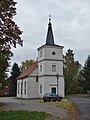
church building in Altwustrow, Brandenburg state, Germany  | |||||
| Upload media | |||||
| Instance of | |||||
|---|---|---|---|---|---|
| Location | Altwustrow, Oderaue, Märkisch-Oderland District, Brandenburg, Germany | ||||
| Heritage designation | |||||
| Inception |
| ||||
 | |||||
This is the category of the Brandenburger Baudenkmal (cultural heritage monument) with the ID 09180310 (Wikidata)
|
English: Church in Altwustrow, Oderaue municipality, Märkisch-Oderland district, Brandenburg state, Germany
Deutsch: Dorfkirche in Altwustrow, Gemeinde Oderaue, Landkreis Märkisch-Oderland, Land Brandenburg, Deutschland.
Français : Église de Altwustrow, commune de Oderaue, arrondissement Märkisch-Pays de l'Oder, état fédéral de Brandebourg, Allemagne
Media in category "Dorfkirche Altwustrow"
The following 6 files are in this category, out of 6 total.
-
 Dorfkirche Altwustrow 2016 E.jpg 3,317 × 3,612; 4.39 MB
-
 Dorfkirche Altwustrow 2016 NW.jpg 4,132 × 4,705; 5.6 MB
-
 Dorfkirche Altwustrow 2016 Portal.jpg 3,624 × 4,846; 5.34 MB
-
 Dorfkirche Altwustrow 2016 SE.jpg 3,166 × 3,460; 3.47 MB
-
 Dorfkirche Altwustrow 2016 W.jpg 2,593 × 3,245; 2.82 MB
-
 Dorfkirche Altwustrow 2016 WNW.jpg 3,648 × 4,864; 6.25 MB


