Category:Dorfkirche Bantikow
| Object location | | View all coordinates using: OpenStreetMap |
|---|
church building in Brandenburg state, Germany  | |||||
| Upload media | |||||
| Instance of | |||||
|---|---|---|---|---|---|
| Location | Bantikow, Wusterhausen/Dosse, Ostprignitz-Ruppin District, Brandenburg, Germany | ||||
| Street address |
| ||||
| Heritage designation | |||||
| Inception |
| ||||
| Width |
| ||||
| Length |
| ||||
| Area |
| ||||
| Religion or worldview | |||||
 | |||||
This is the category of the Brandenburger Baudenkmal (cultural heritage monument) with the ID 09170513 (Wikidata)
|
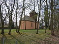
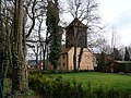
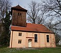
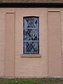
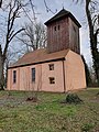
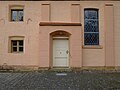
English: Pictures of the church in Bantikow, Wusterhausen/Dosse municipality, Ostprignitz-Ruppin district, Brandenburg state, Germany.
Deutsch: Ansichten der Kirche in Bantikow, Gemeinde Wusterhausen/Dosse, Landkreis Ostprignitz-Ruppin, Land Brandenburg, Deutschland.
Français : Photos de l'église à Bantikow, commune de Wusterhausen/Dosse, arrondissement de Ostprignitz-Ruppin, état federé de Brandebourg, Allemagne.
Español: Vistas de la iglesia en Bantikow, municipio de Wusterhausen/Dosse, distrito de Ostprignitz-Ruppin, estado federado de Brandeburgo, Alemania.
Address:
Dorfstraße 40, 16868 Bantikow
Pages in category "Dorfkirche Bantikow"
This category contains only the following page.
Media in category "Dorfkirche Bantikow"
The following 14 files are in this category, out of 14 total.
-
 Bantikow church 2016 E.JPG 3,648 × 4,864; 8.22 MB
-
 Bantikow church 2016 ESE.JPG 3,648 × 4,864; 7.76 MB
-
 Bantikow church 2016 N.jpg 5,146 × 3,888; 8.89 MB
-
 Bantikow church 2016 NE.JPG 4,864 × 3,648; 8.97 MB
-
 Bantikow church 2016 NW.JPG 4,864 × 3,648; 8.3 MB
-
 Bantikow church 2016 Portal.JPG 3,648 × 4,864; 4.88 MB
-
 Bantikow church 2016 S.jpg 4,743 × 4,131; 10.23 MB
-
 Bantikow church 2016 SE.JPG 4,864 × 3,648; 9.12 MB
-
 Dorfkirche Bantikow 2024 NE.jpg 2,736 × 3,648; 3.62 MB
-
 Dorfkirche Bantikow 2024 Nordfenster.jpg 2,736 × 3,648; 3.23 MB
-
 Dorfkirche Bantikow 2024 NW.jpg 3,024 × 4,032; 4.52 MB
-
 Dorfkirche Bantikow 2024 Portal.jpg 3,648 × 2,736; 3.37 MB
-
 Dorfkirche Bantikow 2024 Südfenster.jpg 2,683 × 3,577; 1.21 MB
-
 Dorfkirche Bantikow 2024 Turmhaube.jpg 2,736 × 3,648; 3.22 MB


