Category:Dorfkirche Boragk in Altenau
| Object location | | View all coordinates using: OpenStreetMap |
|---|
church building in Brandenburg state, Germany  | |||||
| Upload media | |||||
| Instance of | |||||
|---|---|---|---|---|---|
| Location | Altenau, Mühlberg/Elbe, Elbe-Elster District, Brandenburg, Germany | ||||
| Street address |
| ||||
| Architectural style | |||||
| Heritage designation | |||||
| Inception |
| ||||
| Width |
| ||||
| Length |
| ||||
| Religion or worldview | |||||
 | |||||
This is the category of the Brandenburger Baudenkmal (cultural heritage monument) with the ID 09135388 (Wikidata)
|
English: Pictures of the church Boragk in Altenau, Mühlberg/Elbe municipality, Elbe-Elster district, Brandenburg state, Germany.
Deutsch: Ansichten der Kirche Boragk in Altenau, Stadt Mühlberg/Elbe , Landkreis Elbe-Elster , Land Brandenburg , Deutschland.
Français : Photos de l'église Boragk à Altenau, ville de Mühlberg/Elbe, , arrondissement de Elbe-Elster , état federé de Brandebourg , Allemagne.
Español: Vistas de la iglesia Boragk en Altenau, ciudad de Mühlberg/Elbe, distrito de Elbe-Elster , estado federado de Brandeburgo , Alemania.
Address:
Dorfstraße 4, Altenau, 04931 Mühlberg/Elbe
Media in category "Dorfkirche Boragk in Altenau"
The following 4 files are in this category, out of 4 total.
-
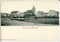 00947-Boragk-1899-total-Brück & Sohn Kunstverlag.jpg 1,424 × 1,000; 355 KB
-
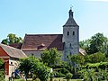 Boragk Dorfkirche.jpg 5,171 × 3,878; 9.17 MB
-
 Boragk Kirche.JPG 3,168 × 4,752; 8.13 MB
-
 Kirchhof Boragk.JPG 4,752 × 3,168; 6.1 MB


