Category:Dorfkirche Britz (Barnim)
| Object location | | View all coordinates using: OpenStreetMap |
|---|
church building in Barnim district, Brandenburg state, Germany  | |||||
| Upload media | |||||
| Instance of | |||||
|---|---|---|---|---|---|
| Location | Britz, Barnim District, Brandenburg, Germany | ||||
| Street address |
| ||||
| Architectural style | |||||
| Heritage designation | |||||
 | |||||
This is the category of the Brandenburger Baudenkmal (cultural heritage monument) with the ID 09175139 (Wikidata)
|
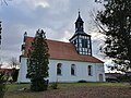
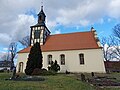
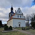
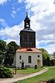
English: Pictures of the church in Britz, Britz municipality, Barnim district, Brandenburg state, Germany. It is owned and used by a Lutheran congregation within the Evangelical Church of Berlin-Brandenburg-Silesian Upper Lusatia, a united Protestant church body of Calvinist, Lutheran and united congregations.
Deutsch: Ansichten der Kirche in Britz, Gemeinde Britz, Landkreis Barnim, Land Brandenburg, Deutschland. Sie gehört und dient einer lutherischen Gemeinde der unierten Evangelischen Kirche Berlin-Brandenburg-Schlesische Oberlausitz.
Français : Photos de l'église à Britz, commune de Britz, arrondissement de Barnim, état fédéral de Brandebourg, Allemagne
Español: Vistas de la iglesia en Britz, municipio de Britz, distrito de Barnim, estado federado de Brandeburgo, Alemania
Address:
Dorfstraße 6, 16230 Britz
Pages in category "Dorfkirche Britz (Barnim)"
This category contains only the following page.
Media in category "Dorfkirche Britz (Barnim)"
The following 17 files are in this category, out of 17 total.
-
 Britz bei Eberswalde 2.JPG 2,560 × 1,920; 996 KB
-
 Britz Kirche 2016.jpg 6,000 × 3,933; 12.71 MB
-
 Dorfkirche Britz (Barnim) 2023 E.jpg 2,947 × 3,930; 1.69 MB
-
 Dorfkirche Britz (Barnim) 2023 Fenster.jpg 2,736 × 3,648; 1.38 MB
-
 Dorfkirche Britz (Barnim) 2023 NNE Panorama.jpg 4,608 × 3,456; 4.07 MB
-
 Dorfkirche Britz (Barnim) 2023 NNE.jpg 4,032 × 3,024; 3.36 MB
-
 Dorfkirche Britz (Barnim) 2023 NNW Panorama.jpg 4,608 × 3,456; 4.77 MB
-
 Dorfkirche Britz (Barnim) 2023 NNW.jpg 2,905 × 3,899; 2.3 MB
-
 Dorfkirche Britz (Barnim) 2023 NW.jpg 2,969 × 3,959; 2.32 MB
-
 Dorfkirche Britz (Barnim) 2023 Portal E.jpg 2,992 × 3,989; 2.42 MB
-
 Dorfkirche Britz (Barnim) 2023 Portal SW.jpg 2,987 × 3,983; 1.59 MB
-
 Dorfkirche Britz (Barnim) 2023 S.jpg 4,608 × 3,456; 2.52 MB
-
 Dorfkirche Britz (Barnim) 2023 SE.jpg 2,990 × 2,990; 1.26 MB
-
 Dorfkirche Britz (Barnim) 2023 SW Panorama.jpg 4,363 × 3,273; 1.68 MB
-
 Dorfkirche Britz (Barnim) 2023 SW.jpg 3,456 × 4,320; 2.03 MB
-
 Dorfkirche Britz (Barnim) 2023 Turm.jpg 2,996 × 3,995; 1 MB
-
 Dorfkirche Britz.jpg 4,000 × 6,000; 10.25 MB

_2023_E.jpg)
_2023_Fenster.jpg)
_2023_NNE_Panorama.jpg)
_2023_NNE.jpg)
_2023_NNW_Panorama.jpg)
_2023_NNW.jpg)
_2023_NW.jpg)
_2023_Portal_E.jpg)
_2023_Portal_SW.jpg)
_2023_S.jpg)
_2023_SE.jpg)
_2023_SW_Panorama.jpg)
_2023_SW.jpg)
_2023_Turm.jpg)
