Category:Dorfkirche Casel
| Object location | | View all coordinates using: OpenStreetMap |
|---|
This is the category of the Brandenburger Baudenkmal (cultural heritage monument) with the ID 09125062 (Wikidata)
|
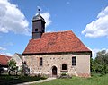
church building in Brandenburg state, Germany   | |||||
| Upload media | |||||
| Instance of | |||||
|---|---|---|---|---|---|
| Location | Casel/Kózle, Drebkau, Spree-Neiße District, Brandenburg, Germany | ||||
| Street address |
| ||||
| Heritage designation | |||||
 | |||||
English: Pictures of the church in Casel, Drebkau municipality, Spree-Neiße district, Brandenburg state, Germany.
Deutsch: Ansichten der Kirche in Casel, Stadt Drebkau, Landkreis Spree-Neiße, Land Brandenburg, Deutschland.
Français : Photos de l'église à Casel, ville de Drebkau, arrondissement de Spree-Neiße, état fédéral de Brandebourg, Allemagne
Español: Vistas de la iglesia en Casel, ciudad de Drebkau, distrito de Spree-Neiße, estado federado de Brandeburgo, Alemania
Address: Calauer Straße 9, Casel, 03116 Drebkau
Subcategories
This category has only the following subcategory.
I
- Interior of Dorfkirche Casel (5 F)
Media in category "Dorfkirche Casel"
The following 8 files are in this category, out of 8 total.
-
 20150513200DR Casel (Drebkau) Dorfkirche.jpg 2,461 × 1,821; 3.72 MB
-
 20150513205DR Casel (Drebkau) Dorfkirche.jpg 2,423 × 1,848; 3.41 MB
-
 20150513210DR Casel (Drebkau) Dorfkirche.jpg 2,410 × 1,911; 3.39 MB
-
 Casel Dorfkirche 01.jpg 4,961 × 3,321; 11.3 MB
-
 Casel Dorfkirche 02.jpg 4,746 × 3,536; 10.52 MB
-
 Casel Dorfkirche 03.jpg 4,489 × 3,453; 8.99 MB
-
 Kózle – wjesna cyrkej 1.jpg 2,800 × 1,867; 1.34 MB
-
 Kózle – wjesna cyrkej 7.jpg 1,867 × 2,800; 1.64 MB
_Dorfkirche.jpg)
_Dorfkirche.jpg)
_Dorfkirche.jpg)


