Category:Dorfkirche Döllingen
| Object location | | View all coordinates using: OpenStreetMap |
|---|
church building in Brandenburg state, Germany  | |||||
| Upload media | |||||
| Instance of | |||||
|---|---|---|---|---|---|
| Location | Döllingen, Plessa, Elbe-Elster District, Brandenburg, Germany | ||||
| Street address |
| ||||
| Architectural style | |||||
| Heritage designation | |||||
| Inception |
| ||||
| Width |
| ||||
| Length |
| ||||
| Area |
| ||||
| Religion or worldview | |||||
 | |||||
This is the category of the Brandenburger Baudenkmal (cultural heritage monument) with the ID 09135367 (Wikidata)
|
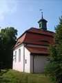
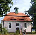
English: Pictures of the church in Döllingen, Plessa municipality, Elbe-Elster district, Brandenburg state, Germany.
Deutsch: Ansichten der Kirche in Döllingen, Stadt Plessa , Landkreis Elbe-Elster , Land Brandenburg , Deutschland.
Français : Photos de l'église à Döllingen, ville de Plessa, , arrondissement de Elbe-Elster , état federé de Brandebourg , Allemagne.
Español: Vistas de la iglesia en Döllingen, ciudad de Plessa, distrito de Elbe-Elster , estado federado de Brandeburgo , Alemania.
Address:
Dorfplatz 4, Döllingen, 04928 Plessa
Media in category "Dorfkirche Döllingen"
The following 8 files are in this category, out of 8 total.
-
 Dorfkirche Döllingen 2.jpg 1,920 × 2,560; 687 KB
-
 Dorfkirche Döllingen 2022-03-25.jpg 5,120 × 2,448; 4.07 MB
-
 Dorfkirche Döllingen 3.jpg 1,920 × 2,560; 941 KB
-
 Dorfkirche Döllingen 4.jpg 1,920 × 2,560; 936 KB
-
 Dorfkirche Döllingen 5.jpg 2,560 × 1,920; 987 KB
-
 Dorfkirche Döllingen.jpg 1,922 × 1,884; 1.76 MB
-
 Epitaph Kirche Döllingen 2.jpg 1,920 × 2,560; 587 KB
-
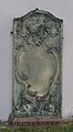 Epitaph Kirche Döllingen.jpg 713 × 1,291; 400 KB


