Category:Dorfkirche Falkenthal
| Object location | | View all coordinates using: OpenStreetMap |
|---|
church buliding in Oberhavel district, Brandenburg state, Germany  | |||||
| Upload media | |||||
| Instance of | |||||
|---|---|---|---|---|---|
| Location | Falkenthal, Löwenberger Land, Oberhavel District, Brandenburg, Germany | ||||
| Street address |
| ||||
| Heritage designation | |||||
| Inception |
| ||||
| Religion or worldview | |||||
 | |||||
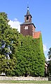
Deutsch: Die Dorfkirche in Falkenthal im Löwenberger Land, Mark Brandenburg, gehört und dient einer Gemeinde der unierten Evangelischen Kirche Berlin-Brandenburg-Schlesische Oberlausitz. Die Kirche entstand im 15. Jh. und wurde 1851 neugotisch überformt.
English: The Village Church in Falkenthal in Löwenberger Land, March of Brandenburg, Germany, is owned and used by a congregation within the Evangelical Church of Berlin-Brandenburg-Silesian Upper Lusatia, a united Protestant church body of Calvinist, Lutheran and united congregations. The church was erected in the 15th c. and was reshaped in new Gothic (not neogothic) style in 1851.
Subcategories
This category has only the following subcategory.
I
Media in category "Dorfkirche Falkenthal"
The following 3 files are in this category, out of 3 total.
-
 Falkenthal church.jpg 2,100 × 2,970; 1.05 MB
-
 Falkenthal Kirche 2006.JPG 557 × 743; 167 KB
-
 Falkenthal Kirche.jpg 454 × 743; 373 KB

