Category:Dorfkirche Fehrow
| Object location | | View all coordinates using: OpenStreetMap |
|---|
church building in Spree-Neiße district, Brandenburg state, Germany  | |||||
| Upload media | |||||
| Instance of | |||||
|---|---|---|---|---|---|
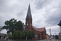
| Location | Fehrow, Schmogrow-Fehrow, Spree-Neiße District, Brandenburg, Germany | ||||
| Street address |
| ||||
| Architectural style | |||||
| Heritage designation | |||||
| Inception |
| ||||
 | |||||
This is the category of the Brandenburger Baudenkmal (cultural heritage monument) with the ID 09125416 (Wikidata)
|
English: Pictures of the church in Fehrow, Schmogrow-Fehrow municipality, Spree-Neiße district, Brandenburg state, Germany.
Deutsch: Ansichten der Kirche in Fehrow, Gemeinde Schmogrow-Fehrow, Landkreis Spree-Neiße, Land Brandenburg, Deutschland.
Français : Photos de l'église à Fehrow, commune de Schmogrow-Fehrow, arrondissement de Spree-Neiße, état fédéral de Brandebourg, Allemagne
Español: Vistas de la iglesia en Fehrow, municipio de Schmogrow-Fehrow, distrito de Spree-Neiße, estado federado de Brandeburgo, Alemania
Address: Hauptstraße 26, Fehrow, 03096 Schmogrow-Fehrow
Media in category "Dorfkirche Fehrow"
The following 3 files are in this category, out of 3 total.
-
 Fehrow (Schmogrow-Fehrow), die Dorfkirche.jpg 2,551 × 1,701; 749 KB
-
 Fehrow 5213.jpg 821 × 1,200; 194 KB
-
 Fehrow Kirche.jpg 3,872 × 2,592; 919 KB
,_die_Dorfkirche.jpg)
