Category:Dorfkirche Görne
| Object location | | View all coordinates using: OpenStreetMap |
|---|
 | |||||
| Upload media | |||||
| Instance of | |||||
|---|---|---|---|---|---|
| Location | Görne, Kleßen-Görne, Havelland District, Brandenburg, Germany | ||||
| Heritage designation | |||||
 | |||||
This is the category of the Brandenburger Baudenkmal (cultural heritage monument) with the ID 09150089 (Wikidata)
|
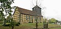
English: Church in Görne, Kleßen-Görne municipality, Havelland district, Brandenburg state, Germany.
Deutsch: Dorfkirche in Görne, Gemeinde Kleßen-Görne, Landkreis Havelland, Land Brandenburg, Deutschland.
Français : Église de Görne, commune de Kleßen-Görne, arrondissement Pays de la Havel, état fédéral de Brandebourg, Allemagne
Media in category "Dorfkirche Görne"
The following 6 files are in this category, out of 6 total.
-
 Dorfkirche Görne 2022-10-01 1.jpg 3,648 × 1,744; 2.52 MB
-
 Dorfkirche Görne 2022-10-01 2.jpg 5,120 × 2,448; 4.48 MB
-
 Gefallenendenkmal Dorfkirche Görne 2022-10-01 3.jpg 5,120 × 2,448; 4.44 MB
-
 Goerne church.jpg 1,470 × 1,950; 441 KB
-
 Görne feb2017 - 7.jpg 4,160 × 2,336; 2.56 MB
-
 Kirche Görne.jpg 3,648 × 1,744; 2.52 MB


