Category:Dorfkirche Grube (Potsdam)
| Object location | | View all coordinates using: OpenStreetMap |
|---|
church building in Potsdam, Brandenburg state, Germany _2016_SE.jpg) | |||||
| Upload media | |||||
| Instance of | |||||
|---|---|---|---|---|---|
| Location | Grube [Potsdam], Potsdam, Brandenburg, Germany | ||||
| Heritage designation | |||||
 | |||||
This is the category of the Brandenburger Baudenkmal (cultural heritage monument) with the ID 09156281 (Wikidata)
|
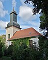
Deutsch: Die Dorfkirche in Grube (zu Potsdam), Mark Brandenburg, gehört und dient einer lutherischen Gemeinde der unierten Evangelischen Kirche Berlin-Brandenburg-Schlesische Oberlausitz. 1745/46 wird die jetzige Kirche als rechteckiger Saalbau aus Backstein errichtet.
English: The Village Church in Grube (a locality of Potsdam), March of Brandenburg, Germany, is owned and used by a Lutheran congregation within the Evangelical Church of Berlin-Brandenburg-Silesian Upper Lusatia, a united Protestant church body of Calvinist, Lutheran and united congregations.
Français : Église de Grube, ville de Potsdam, arrondissement Pays de la Havel, état fédéral de Brandebourg, Allemagne
Media in category "Dorfkirche Grube (Potsdam)"
The following 10 files are in this category, out of 10 total.
-
 Dorfkirche Grube (Potsdam) 2016 Portal S.jpg 3,490 × 4,750; 8.04 MB
-
 Dorfkirche Grube (Potsdam) 2016 Portal W.jpg 3,530 × 4,778; 5.91 MB
-
 Dorfkirche Grube (Potsdam) 2016 SE.jpg 3,108 × 3,879; 5.22 MB
-
 Dorfkirche Grube (Potsdam) 2016 SSW.jpg 6,052 × 5,920; 13.29 MB
-
 Grube Kirche 1.jpg 4,000 × 3,000; 4.31 MB
-
 Kirche Grube.jpg 5,472 × 3,648; 9.83 MB
-
 Potsdam Dorfkirche Grube asv2024-03 img1.jpg 4,489 × 4,489; 10.58 MB
-
 Potsdam Dorfkirche Grube asv2024-03 img2.jpg 4,448 × 5,931; 15.25 MB
-
 Potsdam-Grube - Dorfkirche.jpg 1,800 × 1,350; 1.92 MB
-
 Potsdam-Grube - Kirche (Church) - geo.hlipp.de - 36886.jpg 480 × 640; 92 KB
_2016_Portal_S.jpg)
_2016_Portal_W.jpg)
_2016_SSW.jpg)


_-_geo.hlipp.de_-_36886.jpg)