Category:Dorfkirche Hoppenrade (Havelland)
| Object location | | View all coordinates using: OpenStreetMap |
|---|
church building in Havelland district, Brandenburg state, Germany  | |||||
| Upload media | |||||
| Instance of | |||||
|---|---|---|---|---|---|
| Location | Wustermark, Havelland District, Brandenburg, Germany | ||||
| Heritage designation | |||||
 | |||||
This is the category of the Brandenburger Baudenkmal (cultural heritage monument) with the ID 09150490 (Wikidata)
|
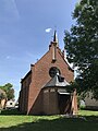
English: Church in Hoppenrade, Wustermark municipality, Havelland district, Brandenburg state, Germany.
Deutsch: Dorfkirche in Hoppenrade, Gemeinde Wustermark, Landkreis Havelland, Land Brandenburg, Deutschland.
Français : Église de Hoppenrade, commune de Wustermark, arrondissement Pays de la Havel, état fédéral de Brandebourg, Allemagne
Media in category "Dorfkirche Hoppenrade (Havelland)"
The following 19 files are in this category, out of 19 total.
-
 Dorfkirche Hoppenrade Anbau Nordansicht.jpg 3,024 × 4,032; 3.55 MB
-
 Dorfkirche Hoppenrade Anbau Südansicht.jpg 3,024 × 4,032; 4.41 MB
-
 Dorfkirche Hoppenrade Anbau Westansicht.jpg 3,024 × 4,032; 4.26 MB
-
 Dorfkirche Hoppenrade Ostansicht.jpg 3,024 × 4,032; 2.52 MB
-
 Dorfkirche Hoppenrade Schiff Nordansicht.jpg 3,024 × 4,032; 3.44 MB
-
 Dorfkirche Hoppenrade Schiff Südansicht.jpg 3,024 × 4,032; 4.26 MB
-
 Dorfkirche Hoppenrade Südansicht.jpg 4,032 × 3,024; 4.12 MB
-
 Dorfkirche Hoppenrade Südosteingang.jpg 3,024 × 4,032; 2.79 MB
-
 Dorfkirche Hoppenrade Südostturm Südansicht.jpg 3,024 × 4,032; 2.88 MB
-
 Dorfkirche Hoppenrade Südostturm Südwestansicht.jpg 3,024 × 4,032; 3.23 MB
-
 Dorfkirche Hoppenrade Westansicht.jpg 3,024 × 4,032; 3.35 MB
-
 Hoppenrade (Havelland) church 2009 SE.jpg 3,872 × 2,592; 1.01 MB
-
 Hoppenrade (Havelland) church 2016 E.jpg 3,648 × 4,864; 6.71 MB
-
 Hoppenrade (Havelland) church 2016 NE.jpg 4,049 × 4,271; 7.82 MB
-
 Hoppenrade (Havelland) church 2016 portal E.jpg 3,648 × 4,864; 5.32 MB
-
 Hoppenrade (Havelland) church 2016 portal W.jpg 3,630 × 4,850; 7.56 MB
-
 Hoppenrade (Havelland) church 2016 SE.jpg 3,529 × 4,250; 6.28 MB
-
 Hoppenrade (Havelland) church 2016 SW.jpg 3,620 × 4,842; 7.31 MB
-
 Hoppenrade (Havelland) church 2016 W.jpg 3,504 × 3,288; 5.88 MB


_church_2009_SE.jpg)
_church_2016_E.jpg)
_church_2016_NE.jpg)
_church_2016_portal_E.jpg)
_church_2016_portal_W.jpg)
_church_2016_SE.jpg)
_church_2016_SW.jpg)
_church_2016_W.jpg)