Category:Dorfkirche Obersdorf (Müncheberg)
| Object location | | View all coordinates using: OpenStreetMap |
|---|
church building in Brandenburg state, Germany  | |||||
| Upload media | |||||
| Instance of | |||||
|---|---|---|---|---|---|
| Location | Q116765806, Müncheberg, Märkisch-Oderland District, Brandenburg, Germany | ||||
| Heritage designation | |||||
 | |||||
This is the category of the Brandenburger Baudenkmal (cultural heritage monument) with the ID 09180006 (Wikidata)
|
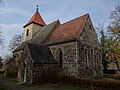
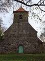
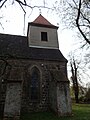
Deutsch: Bilder der Kirche in Obersdorf, Stadt Müncheberg, Landkreis Märkisch-Oderland, Land Brandenburg, Deutschland.
English: Pictures of the church in Obersdorf, Müncheberg municipality, Märkisch-Oderland district, Brandenburg state, Germany
Français : Photos de l'église à Obersdorf, ville de Müncheberg, arrondissement de Märkisch-Oderland, état fédéral de Brandebourg, Allemagne
Subcategories
This category has only the following subcategory.
Media in category "Dorfkirche Obersdorf (Müncheberg)"
The following 17 files are in this category, out of 17 total.
-
 Dorfkirche Obersdorf Chor Nordansicht.jpg 4,608 × 3,456; 6.07 MB
-
 Dorfkirche Obersdorf Chor Südansicht mit Sakristei.jpg 4,608 × 3,456; 6.04 MB
-
 Dorfkirche Obersdorf Denkmal Findling WK II.jpg 4,608 × 3,456; 6.65 MB
-
 Dorfkirche Obersdorf Denkmal WK I.jpg 4,608 × 3,456; 6.47 MB
-
 Dorfkirche Obersdorf Denkmal WK II.jpg 4,608 × 3,456; 6.81 MB
-
 Dorfkirche Obersdorf Einfriedung.jpg 4,608 × 3,456; 6.09 MB
-
 Dorfkirche Obersdorf Informationstafel.jpg 3,456 × 4,608; 4.96 MB
-
 Dorfkirche Obersdorf Kirchenschiff Nordansicht.jpg 4,608 × 3,456; 5.58 MB
-
 Dorfkirche Obersdorf Kirchenschiff Südansicht.jpg 4,608 × 3,456; 6.29 MB
-
 Dorfkirche Obersdorf Nordostansicht.jpg 4,608 × 3,456; 5.72 MB
-
 Dorfkirche Obersdorf Ostansicht.jpg 4,608 × 3,456; 6.02 MB
-
 Dorfkirche Obersdorf Südostansicht.jpg 4,608 × 3,456; 5.65 MB
-
 Dorfkirche Obersdorf Westansicht.jpg 3,456 × 4,608; 5.71 MB
-
 Dorfkirche Obersdorf Westportal.jpg 4,608 × 3,456; 5.87 MB
-
 Dorfkirche Obersdorf Westturm Nordansicht.jpg 3,456 × 4,608; 3.39 MB
-
 Dorfkirche Obersdorf Westturm Südansicht.jpg 3,456 × 4,608; 5.65 MB
-
 Obersdorf Dorfkirche.JPG 3,648 × 2,736; 1.67 MB


