Category:Dorfkirche Reichenow
| Object location | | View all coordinates using: OpenStreetMap |
|---|
church building in Reichenow-Möglin, Brandenburg state, Germany  | |||||
| Upload media | |||||
| Instance of | |||||
|---|---|---|---|---|---|
| Location | Reichenow, Reichenow-Möglin, Märkisch-Oderland District, Brandenburg, Germany | ||||
| Heritage designation | |||||
 | |||||
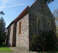
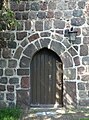
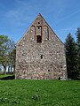
English: Pictures of the church in Reichenow , Reichenow-Möglin municipality , Märkisch-Oderland district, Brandenburg state, Germany.
Deutsch: Ansichten der Kirche in Reichenow , Gemeinde Reichenow-Möglin , Landkreis Märkisch-Oderland , Land Brandenburg, Deutschland.
Français : Photos de l'église à Reichenow , commune de Reichenow-Möglin , arrondissement de Märkisch-Oderland , état fédéral de Brandebourg, Allemagne
Español: Vistas de la iglesia en Reichenow , municipio de Reichenow-Möglin , distrito de Märkisch-Oderland , estado federado de Brandeburgo, Alemania
This is the category of the Brandenburger Baudenkmal (cultural heritage monument) with the ID 09180633 (Wikidata)
|
Address:
Dorfstraße 7, Reichenow, 15345 Reichenow-Möglin
Pages in category "Dorfkirche Reichenow"
This category contains only the following page.
Media in category "Dorfkirche Reichenow"
The following 8 files are in this category, out of 8 total.
-
 Dorfkirche Reichenow 2018 ESE.jpg 5,269 × 4,817; 9.55 MB
-
 Dorfkirche Reichenow 2018 N.jpg 4,164 × 4,222; 7.96 MB
-
 Dorfkirche Reichenow 2018 Portal W vermauert.jpg 3,648 × 4,864; 8.86 MB
-
 Dorfkirche Reichenow 2018 S.jpg 5,818 × 4,627; 11.71 MB
-
 Dorfkirche Reichenow 2018 SW.jpg 4,443 × 4,686; 9.91 MB
-
 Dorfkirche Reichenow 2018 Südportal.jpg 3,568 × 4,804; 6.99 MB
-
 Dorfkirche Reichenow 2018 W.jpg 3,648 × 4,864; 7.65 MB
-
 Dorfkirche Reichenow 2018 WNW.jpg 4,142 × 4,547; 9.38 MB


