Category:Drainage basin maps of Sweden
Countries of Europe: Armenia‡ · Azerbaijan‡ · Bosnia and Herzegovina · Czech Republic · Finland · France‡ · Georgia‡ · Germany · Italy · Latvia · Lithuania · Norway · Poland · Portugal‡ · Romania · Slovakia · Spain‡ · Sweden · Switzerland · Turkey‡ · Ukraine · United Kingdom
‡: partly located in Europe
‡: partly located in Europe
Українська: Данна категорія містить карти річкових басейнів Швеції.
Media in category "Drainage basin maps of Sweden"
The following 35 files are in this category, out of 35 total.
-
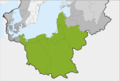 Becken der südlichen Ostsee.png 1,542 × 1,039; 272 KB
-
 Becken der südlichen südöstliche Ostsee (deutsch).png 1,542 × 1,039; 296 KB
-
 Becken entlang Warnow Peene Oder-Mündung Weichsel-Mündung.png 1,543 × 1,038; 271 KB
-
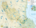 Dalälven drainage basin administrative map-fr.svg 3,543 × 2,803; 3.56 MB
-
 Dalälven drainage basin map-fr.svg 3,543 × 2,803; 3.55 MB
-
 Dalälven drainage basin topographic map-fr.svg 3,543 × 2,803; 3.57 MB
-
 Drainage basins in Sweden.png 2,245 × 3,179; 436 KB
-
 Drainage basins in Sweden.svg 2,105 × 2,980; 6.28 MB
-
 Flians vattenområde 1-160000.jpg 1,261 × 1,323; 859 KB
-
 Lidans vattenområde 1-160000.jpg 1,555 × 1,657; 1.07 MB
-
 Map of the Höje River – UK – Карта річки Гейє.gif 612 × 600; 34 KB
-

-

-
 Map of the river Bäveån – UK – Карта річки Бевеон.gif 1,098 × 721; 66 KB
-
 Map of the river Fylleån – UK – Карта річки Фюллеон.gif 667 × 584; 37 KB
-
 Map of the river Gothemsån – UK – Карта річки Гутгемсон.gif 755 × 922; 47 KB
-
 Map of the river Himleån - SV - Karta över Himleån.gif 754 × 560; 34 KB
-
 Map of the river Himleån – UK – Карта річки Гімлеон.gif 754 × 560; 35 KB
-
 Map of the river Keräsjoki – UK – Карта річки Кересйокі.png 441 × 624; 156 KB
-
 Map of the river Kungsbackaån – UK – Карта річки Кунгсбакаон.gif 978 × 628; 62 KB
-
 Map of the river Rolfsån – UK – Карта річки Рольфсон.GIF 636 × 661; 46 KB
-
 Map of the river Råån – UK – Карта річки Роон.gif 483 × 435; 22 KB
-
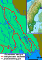
 Map of the river Sangisälven – UK – Карта річки Сангісельвен.png 612 × 954; 200 KB
-
 Map of the river Saxån – UK – Карта річки Саксон.gif 1,103 × 721; 49 KB
-
 Map of the river Snoderån – UK – Карта річки Снудерон.gif 755 × 922; 46 KB
-
 Map of the river Stensån – UK – Карта річки Стенсон.gif 846 × 617; 40 KB
-
 Map of the river Suseån – UK – Карта річки Сусеон.gif 621 × 697; 37 KB
-
 Map of the river Virån – UK – Карта річки Вірон.gif 643 × 513; 37 KB
-
 Map of the river Örekilsälven – UK – Карта річки Еречілсельвен.gif 724 × 781; 62 KB
-
 Map of the Sege River – UK – Карта річки Сеге.gif 1,020 × 721; 48 KB
-
 Map of the Vege River – UK – Карта річки Веге.gif 563 × 649; 38 KB
-
 Moälven map.png 1,520 × 1,681; 418 KB
-
 Nätraån map.png 1,482 × 810; 211 KB
-
 Avrinning-Örekilsälven.svg 724 × 781; 114 KB
-

.png)


