Category:Ellesmere Rural
English: Ellesmere Rural is a civil parish in the county of Shropshire, England.

civil parish in Shropshire, United Kingdom | |||||
| Upload media | |||||
| Instance of | |||||
|---|---|---|---|---|---|
| Location | Shropshire, West Midlands, England | ||||
 | |||||
Subcategories
This category has the following 11 subcategories, out of 11 total.
Media in category "Ellesmere Rural"
The following 200 files are in this category, out of 216 total.
(previous page) (next page)-
 'Romantic Lady' at Maestermyn - geograph.org.uk - 5344313.jpg 1,280 × 851; 427 KB
-
 A495 east approaching Ellesmere - geograph.org.uk - 2899310.jpg 640 × 483; 117 KB
-
 A495 east approaching The Brow - geograph.org.uk - 2899219.jpg 640 × 429; 56 KB
-

-
 A495 near The Brow - geograph.org.uk - 4436783.jpg 640 × 346; 54 KB
-
 A528 crossroads near Whitemere - geograph.org.uk - 4264755.jpg 640 × 481; 76 KB
-
 A528 northbound at Wood Lane - geograph.org.uk - 4264750.jpg 640 × 481; 66 KB
-
 A528 northbound Festive signs - geograph.org.uk - 4264748.jpg 640 × 479; 119 KB
-

-
 A528 south approaching A495 junction - geograph.org.uk - 2899328.jpg 640 × 466; 98 KB
-
 A528-A495 junction - geograph.org.uk - 4264757.jpg 640 × 481; 71 KB
-
 Approaching Newnes road junction - geograph.org.uk - 4436792.jpg 640 × 337; 66 KB
-
 Approaching Sandhole Farm - geograph.org.uk - 5752938.jpg 640 × 480; 89 KB
-
 Autumn, Red Hall Lane - geograph.org.uk - 5199186.jpg 5,184 × 3,456; 4.4 MB
-
 Autumnal oak - geograph.org.uk - 5976702.jpg 5,184 × 3,888; 4.36 MB
-
 Autumnal oak - geograph.org.uk - 5976718.jpg 5,184 × 3,888; 4.28 MB
-
 B5068 Ellesmere to St Martins road - geograph.org.uk - 6507584.jpg 5,184 × 3,888; 4.08 MB
-
 B5069 from Flannog Lane - geograph.org.uk - 2171993.jpg 640 × 480; 90 KB
-
 Bank Farm - geograph.org.uk - 3618022.jpg 1,024 × 768; 130 KB
-
 Bare trees south of Colemere - geograph.org.uk - 4267649.jpg 1,024 × 768; 170 KB
-
 Barn at Elson Farm - geograph.org.uk - 6436526.jpg 5,184 × 3,888; 4.79 MB
-
 Barn at Hardwick Hall Farm - geograph.org.uk - 6454652.jpg 5,184 × 3,888; 2.97 MB
-
 Beech House, Llangollen Canal.jpg 640 × 480; 86 KB
-
 Beside the Llangollen Canal - geograph.org.uk - 2919616.jpg 640 × 480; 67 KB
-
 Between high hedges - geograph.org.uk - 5976723.jpg 5,184 × 3,888; 5.33 MB
-
 Between high hedges - geograph.org.uk - 6454640.jpg 5,184 × 3,888; 4.41 MB
-
 Bonus Buzzard - geograph.org.uk - 537836.jpg 640 × 427; 37 KB
-
 Broome Farm - geograph.org.uk - 5959361.jpg 1,024 × 683; 322 KB
-
 Buildings at Frankton Farm - geograph.org.uk - 2901976.jpg 640 × 480; 114 KB
-
 Caegoody Lane - geograph.org.uk - 5960174.jpg 1,024 × 683; 466 KB
-

-

-

-
 Canal overflow with ducks - geograph.org.uk - 5459753.jpg 1,280 × 874; 993 KB
-
 Canal signpost near Ellesmere in Shropshire - geograph.org.uk - 5464075.jpg 960 × 1,280; 1.13 MB
-
 Canal towpath near Ellesmere - geograph.org.uk - 4179596.jpg 640 × 360; 50 KB
-

-
 Canalside pasture west of Lower Frankton, Shropshire - geograph.org.uk - 5251545.jpg 1,280 × 836; 1.14 MB
-

-

-
 Cattle, Sand Hole Farm, New Marton - geograph.org.uk - 4243941.jpg 1,600 × 1,022; 322 KB
-
 Church and churchyard - geograph.org.uk - 6507561.jpg 5,184 × 3,888; 3.72 MB
-
 Colemere, A528 Cockshutt to Ellesmere Road - geograph.org.uk - 6137254.jpg 3,613 × 2,409; 1.82 MB
-
 Colemere, Fields of oil seed rape - geograph.org.uk - 6137269.jpg 640 × 427; 56 KB
-
 Commercial units in Ellesmere Business Park - geograph.org.uk - 5928823.jpg 1,080 × 810; 118 KB
-
 Country lane in autumn - geograph.org.uk - 5976709.jpg 5,184 × 3,888; 6.94 MB
-
 Cow path, Old Hardwick - geograph.org.uk - 4211204.jpg 800 × 600; 410 KB
-
 Daffodils by the road - geograph.org.uk - 6441450.jpg 5,184 × 3,888; 6.05 MB
-
 Dutch barn at Spout Farm - geograph.org.uk - 6415492.jpg 5,184 × 3,888; 3.74 MB
-
 Eastern turning for Newnes - geograph.org.uk - 2899283.jpg 640 × 450; 81 KB
-
 Ellesmere boatyard - geograph.org.uk - 6442161.jpg 5,184 × 3,888; 4.95 MB
-
 Ellesmere Business Park - geograph.org.uk - 5960164.jpg 1,024 × 683; 273 KB
-
 Empty farmyard at Lee Bridges - geograph.org.uk - 6441419.jpg 5,184 × 3,888; 3.81 MB
-
 Entrance to The Chestnuts from A495 - geograph.org.uk - 4436759.jpg 640 × 296; 62 KB
-
 Farm sign, Sandhole Farm - geograph.org.uk - 5752944.jpg 640 × 480; 69 KB
-
 Farmhouse near Spunhill, Shropshire - geograph.org.uk - 3724976.jpg 1,024 × 659; 159 KB
-
 Farmland north of Birch Hall, near Ellesmere - geograph.org.uk - 5212071.jpg 1,024 × 614; 103 KB
-
 Field and lane south of Ellesmere - geograph.org.uk - 2898603.jpg 640 × 480; 107 KB
-
 Field edge - geograph.org.uk - 6415501.jpg 5,184 × 3,888; 4.82 MB
-
 Field in winter - geograph.org.uk - 6349116.jpg 4,032 × 3,024; 1.31 MB
-
 Field near New Crickett - geograph.org.uk - 4219041.jpg 800 × 600; 401 KB
-
 Field of maize, New Marton - geograph.org.uk - 5752960.jpg 640 × 480; 103 KB
-
 Field of rape, Eastwick Farm - geograph.org.uk - 6439114.jpg 5,184 × 3,888; 5.53 MB
-
 Field of wheat - geograph.org.uk - 6507572.jpg 5,184 × 3,888; 4.21 MB
-
 Field split between crops - geograph.org.uk - 3618181.jpg 1,600 × 1,200; 599 KB
-
 Field west of the A528 - geograph.org.uk - 6439119.jpg 5,184 × 3,888; 5.54 MB
-
 Flannog Lane at Street Dinas - geograph.org.uk - 2171995.jpg 640 × 480; 86 KB
-
 Forage maize - geograph.org.uk - 4211168.jpg 800 × 600; 378 KB
-
 Forage maize, Ellesmere - geograph.org.uk - 5959446.jpg 1,024 × 683; 337 KB
-
 Ford around the corner - geograph.org.uk - 6507566.jpg 5,184 × 3,888; 4.81 MB
-
 Ford at Bryn Daniel - geograph.org.uk - 4039795.jpg 3,872 × 2,592; 4.75 MB
-
 Ford at Plas-Thomas - geograph.org.uk - 4041408.jpg 3,872 × 2,592; 4.65 MB
-
 Ford through stream bed - geograph.org.uk - 3617923.jpg 3,264 × 2,448; 5.09 MB
-
 Fork near New Crickett - geograph.org.uk - 4211182.jpg 800 × 600; 347 KB
-
 Frankton Farm in Shropshire - geograph.org.uk - 5460921.jpg 1,280 × 862; 1.18 MB
-
 Gate piers near Ellesmere - geograph.org.uk - 2136574.jpg 640 × 369; 193 KB
-
 Gorse by the canal - geograph.org.uk - 6442158.jpg 5,184 × 3,888; 3.72 MB
-
 Grassland, Pentre-coed - geograph.org.uk - 4211057.jpg 800 × 600; 361 KB
-
 Grazing field by Flannog Farm - geograph.org.uk - 3617727.jpg 3,264 × 2,448; 4.36 MB
-
 Grazing field from the Llwybr Maelor Way - geograph.org.uk - 3617897.jpg 3,264 × 2,448; 4.2 MB
-
 Grazing field from the Llwybr Maelor Way - geograph.org.uk - 3617915.jpg 1,600 × 1,200; 582 KB
-
 Grazings near Gadlas - geograph.org.uk - 367163.jpg 640 × 480; 79 KB
-
 Greyhound Inn Street Dinas - geograph.org.uk - 2171988.jpg 640 × 480; 67 KB
-
 Heading south out of Tetchill - geograph.org.uk - 6454637.jpg 5,067 × 3,779; 3.51 MB
-
 Junction of the A495 - geograph.org.uk - 6454649.jpg 5,184 × 3,888; 4.29 MB
-
 Landing stages at White Mere Lake - geograph.org.uk - 4646871.jpg 3,264 × 2,448; 3.46 MB
-
 Lane at New Marton - geograph.org.uk - 5752937.jpg 640 × 480; 110 KB
-
 Lane near Manor Farm - geograph.org.uk - 4219072.jpg 800 × 600; 400 KB
-
 Lane, Pentre-coed - geograph.org.uk - 4211109.jpg 640 × 480; 65 KB
-
 Lane, Tetchill - geograph.org.uk - 4219062.jpg 800 × 600; 377 KB
-
 Lee Bridges Methodist Chapel - geograph.org.uk - 6441417.jpg 640 × 480; 78 KB
-
 Lee New Farm - geograph.org.uk - 537607.jpg 640 × 364; 87 KB
-
 Lee Old Hall - geograph.org.uk - 6441414.jpg 5,184 × 3,888; 4.84 MB
-
 Looking towards Lee New Farm. - geograph.org.uk - 537591.jpg 427 × 640; 128 KB
-
 Looking towards Mere Wood - geograph.org.uk - 6444957.jpg 5,184 × 3,888; 4.08 MB
-
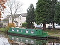
 Moored narrowboat near Ellesmere, Shropshire - geograph.org.uk - 5246591.jpg 1,280 × 850; 800 KB
-
 Moored narrowboat south of Ellesmere, Shropshire - geograph.org.uk - 5464031.jpg 1,280 × 960; 1.15 MB
-

-
 Moorings by the Jack Mytton Inn - geograph.org.uk - 5752973.jpg 640 × 480; 134 KB
-
 Moorings north-west of Tetchill in Shropshire - geograph.org.uk - 5463497.jpg 1,280 × 889; 1.28 MB
-
 Moorings north-west of Tetchill in Staffordshire - geograph.org.uk - 5463494.jpg 1,280 × 960; 1.42 MB
-
 Narrow boat moored by The Narrow Boat pub - geograph.org.uk - 5976716.jpg 5,184 × 3,888; 5.78 MB
-
 Narrow boats moored NE of Coachman's Bridge - geograph.org.uk - 6442151.jpg 5,184 × 3,888; 4.7 MB
-
 Narrowboat at Frankton Junction, Shropshire - geograph.org.uk - 5251157.jpg 1,280 × 887; 972 KB
-
 Narrowboats near Ellesmere - geograph.org.uk - 6178218.jpg 800 × 533; 687 KB
-
 Nature returns - geograph.org.uk - 6436532.jpg 5,184 × 3,888; 5.57 MB
-
 New cattle shed at Broome Farm - geograph.org.uk - 5212864.jpg 1,024 × 768; 108 KB
-
 New housing at Ellesmere in Shropshire - geograph.org.uk - 5464056.jpg 1,440 × 840; 1.05 MB
-
 New Marton Hall - geograph.org.uk - 5752950.jpg 640 × 480; 70 KB
-
-
-
 Old Coptiviney - geograph.org.uk - 532679.jpg 640 × 391; 60 KB
-
 Old Coptiviney - geograph.org.uk - 6415490.jpg 4,666 × 3,509; 3.49 MB
-
 Old Coptiviney - geograph.org.uk - 6446699.jpg 5,184 × 3,888; 3.57 MB
-
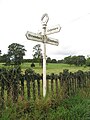 Old Direction Sign - Signpost - geograph.org.uk - 6049868.jpg 600 × 800; 80 KB
-

-
 On the Llangollen Canal - geograph.org.uk - 2919599.jpg 640 × 480; 80 KB
-
 On the Llwybr Maelor Way - geograph.org.uk - 3617740.jpg 1,600 × 1,200; 658 KB
-
 Ordnance Survey Cut Mark - geograph.org.uk - 5231378.jpg 4,000 × 3,000; 3.83 MB
-

-
 Park Hall access track - geograph.org.uk - 6415499.jpg 5,184 × 3,888; 3.93 MB
-

-

-
 Passing through the Hardwick Estate - geograph.org.uk - 6454655.jpg 5,029 × 3,787; 3.35 MB
-
 Pastoral Scene - geograph.org.uk - 537819.jpg 640 × 427; 52 KB
-
 Pasture and canal west of New Marton, Shropshire - geograph.org.uk - 4851449.jpg 1,280 × 726; 794 KB
-

-
 Pasture by Maestermyn Bridge, Shropshire - geograph.org.uk - 5252416.jpg 1,280 × 900; 1.01 MB
-
 Pasture east of Hindford, Shropshire - geograph.org.uk - 4850498.jpg 1,280 × 932; 942 KB
-
 Pasture east of Lower Frankton in Shropshire - geograph.org.uk - 5461938.jpg 1,280 × 849; 791 KB
-
 Pasture near Lower Frankton in Shropshire - geograph.org.uk - 5460967.jpg 1,280 × 848; 987 KB
-
 Pasture near Lower Frankton in Shropshire - geograph.org.uk - 5460972.jpg 1,280 × 814; 999 KB
-
 Pasture near Lower Frankton in Shropshire - geograph.org.uk - 5461045.jpg 1,280 × 712; 792 KB
-
 Pasture south-east of Tetchill, Shropshire - geograph.org.uk - 5462091.jpg 1,280 × 896; 908 KB
-
 Pasture south-east of Tetchill, Shropshire - geograph.org.uk - 5462098.jpg 1,280 × 736; 904 KB
-
 Pasture south-west of Tetchill, Shropshire - geograph.org.uk - 5248552.jpg 1,280 × 898; 848 KB
-
 Pasture south-west of Welsh Frankton, Shropshire - geograph.org.uk - 5460844.jpg 1,280 × 830; 1.03 MB
-
 Pasture west of Lower Frankton, Shropshire - geograph.org.uk - 5251536.jpg 1,280 × 856; 872 KB
-
 Pasture west of Lower Frankton, Shropshire - geograph.org.uk - 5251543.jpg 1,280 × 856; 886 KB
-
 Pentre Morgan - geograph.org.uk - 248683.jpg 640 × 480; 105 KB
-
 Pentre-coed - geograph.org.uk - 4211068.jpg 800 × 600; 400 KB
-
 Pentre-coed - geograph.org.uk - 4219026.jpg 800 × 600; 442 KB
-
 Pentre-coed to Gadlas road - geograph.org.uk - 4211125.jpg 800 × 600; 415 KB
-
 Ploughed field SW of Eastwick Lane - geograph.org.uk - 6439116.jpg 5,184 × 3,888; 5.13 MB
-
 Pond in a field - geograph.org.uk - 3618201.jpg 1,024 × 768; 343 KB
-
-
 Private woodland - geograph.org.uk - 6415497.jpg 5,184 × 3,888; 6.21 MB
-
 Pub Sign at The Greyhound Inn - geograph.org.uk - 2171998.jpg 480 × 640; 96 KB
-
 Public footpath beside a field of sweetcorn - geograph.org.uk - 3618173.jpg 1,600 × 1,200; 556 KB
-
 Quiet on the canal - geograph.org.uk - 6442143.jpg 5,184 × 3,888; 5.23 MB
-
 Red Hall Lane in spring - geograph.org.uk - 6439113.jpg 3,888 × 5,184; 6.21 MB
-
 Road at Pentre-coed - geograph.org.uk - 5231365.jpg 4,000 × 3,000; 4.35 MB
-
 Road between Pentre Morgan and Bryn Goleau - geograph.org.uk - 5231401.jpg 4,000 × 3,000; 2.56 MB
-
 Road junction near Gannow Hill - geograph.org.uk - 2899182.jpg 640 × 469; 65 KB
-
 Road junction south of The Mere - geograph.org.uk - 4436908.jpg 640 × 405; 91 KB
-
 Road near New Marton Triangulation Pillar - geograph.org.uk - 5231436.jpg 4,000 × 3,000; 3.73 MB
-
 Road with Bridge over Shell Brook near Pentre Farm - geograph.org.uk - 5231362.jpg 4,000 × 3,000; 4.45 MB
-
 Road, pylon, pub and canal near Welsh Frankton - geograph.org.uk - 5252624.jpg 1,280 × 847; 1.03 MB
-
 Roadside celandines - geograph.org.uk - 6436522.jpg 3,888 × 5,184; 6.31 MB
-
 Rock Farm - geograph.org.uk - 3618193.jpg 1,600 × 1,200; 537 KB
-

-
 Sand Hole Farm, New Marton - geograph.org.uk - 4243930.jpg 1,600 × 1,080; 275 KB
-

-
 Service road, Elson - geograph.org.uk - 5960168.jpg 1,024 × 683; 336 KB
-
 Seven Sisters - geograph.org.uk - 5727930.jpg 1,600 × 1,199; 674 KB
-
 Seven Sisters, Ellesmere - geograph.org.uk - 5117568.jpg 5,133 × 3,422; 5.98 MB
-
 Shell Brook, Knolton Wood - geograph.org.uk - 5185481.jpg 5,279 × 3,602; 3.6 MB
-
 Shropshire farmland east of Hindford - geograph.org.uk - 4678664.jpg 1,024 × 605; 434 KB
-
 Shropshire farmland near Tetchill - geograph.org.uk - 5247719.jpg 1,280 × 858; 733 KB
-
 Shropshire farmland south of Ellesmere - geograph.org.uk - 6121364.jpg 4,000 × 3,000; 2.29 MB
-

-
 Silage stash - geograph.org.uk - 4211140.jpg 800 × 600; 360 KB
-
 Sodylt Old Hall near Sodylt Bank - geograph.org.uk - 6010703.jpg 5,184 × 2,920; 6.29 MB
-
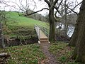
 Stile on footpath - geograph.org.uk - 3618192.jpg 3,264 × 2,448; 4.49 MB
-
 Straight road to Manor Farm - geograph.org.uk - 6441427.jpg 5,184 × 3,888; 5.25 MB
-
 Stubble field east of Hindford, Shropshire - geograph.org.uk - 4849325.jpg 1,280 × 861; 974 KB
-
 Stubble field east of Hindford, Shropshire - geograph.org.uk - 4849331.jpg 1,024 × 768; 609 KB
-
 Telephone box at Lee, in Ellesmere Rural, Shropshire, England.jpg 427 × 640; 167 KB
-
 Temporary sheep pens - geograph.org.uk - 6415506.jpg 5,184 × 3,888; 5.81 MB
-
 Tetchill Brook - geograph.org.uk - 4219053.jpg 800 × 600; 462 KB
-
 Tetchill Moor - geograph.org.uk - 4219069.jpg 640 × 480; 286 KB
-
 Tetchill Road junction - geograph.org.uk - 2899250.jpg 640 × 402; 64 KB
-
 Tetchill to Hordley road - geograph.org.uk - 5959349.jpg 1,024 × 1,024; 629 KB
-
 The A495 to Oswestry, Shropshire - geograph.org.uk - 5252420.jpg 1,280 × 724; 932 KB
-
 The canal near Ellesmere - geograph.org.uk - 4179580.jpg 640 × 360; 59 KB
-
 The Llwybr Maelor Way - geograph.org.uk - 3617712.jpg 1,600 × 1,200; 745 KB
-
 The Llwybr Maelor Way - geograph.org.uk - 3617909.jpg 3,264 × 2,448; 6.03 MB
-
 The Narrow Boat, Maestermyn - geograph.org.uk - 5344278.jpg 1,280 × 851; 408 KB
-
 The Narrow Boat, Maestermyn Bridge - geograph.org.uk - 5949385.jpg 1,280 × 851; 337 KB
-
 The Oaks - geograph.org.uk - 2542234.jpg 4,000 × 3,000; 2.3 MB
-
 The Old Junction House - geograph.org.uk - 6442045.jpg 1,080 × 810; 151 KB
-

-

-
 The Vyrnwy aqueduct access point - geograph.org.uk - 2600179.jpg 4,288 × 3,216; 6.91 MB
-
 Timber storage at the sawmill - geograph.org.uk - 6436517.jpg 5,184 × 3,888; 4.16 MB
-
 Towards Colemere Woods - geograph.org.uk - 537805.jpg 640 × 427; 116 KB
-
 Tractor in the farmyard - geograph.org.uk - 6441412.jpg 5,184 × 3,888; 3.3 MB
-
 Tree in a pasture field, south of Ellesmere - geograph.org.uk - 5212097.jpg 1,024 × 768; 150 KB
-
 Tree in field corner - geograph.org.uk - 6416005.jpg 5,184 × 3,888; 5.36 MB
-
 Trees along a hedgerow, near the Claypits - geograph.org.uk - 5212836.jpg 1,024 × 768; 116 KB


_-_geograph.org.uk_-_2839141.jpg)


