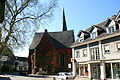
Category:Evangelische Kirche Ründeroth
| Object location | | View all coordinates using: OpenStreetMap |
|---|
_(01).jpg) | |||||
| Upload media | |||||
| Instance of | |||||
|---|---|---|---|---|---|
| Location | Ründeroth, Engelskirchen, Oberbergischer Kreis, Cologne Government Region, North Rhine-Westphalia, Germany | ||||
| Heritage designation | |||||
 | |||||
Media in category "Evangelische Kirche Ründeroth"
The following 17 files are in this category, out of 17 total.
-
 Engelskirchen Ründeroth - Hauptstraße - evangelische Kirche 01 ies.jpg 3,888 × 2,592; 5.83 MB
-
 Engelskirchen Ründeroth - Hauptstraße - evangelische Kirche 02 ies.jpg 3,888 × 2,592; 3.65 MB
-
 Engelskirchen Ründeroth - Hauptstraße - evangelische Kirche 03 ies.jpg 3,888 × 2,592; 5.46 MB
-
 Engelskirchen Ründeroth - Hauptstraße - evangelische Kirche 04 ies.jpg 2,592 × 3,888; 3.25 MB
-
 Ev Kirche Runderoth.JPG 2,601 × 3,901; 1.91 MB
-
 Evangelische Kirche (Ründeroth) (01).jpg 3,417 × 2,847; 1.81 MB
-
 Evangelische Kirche (Ründeroth) (02).jpg 2,385 × 3,221; 1.58 MB
-
 Evangelische Kirche (Ründeroth) (03).jpg 2,284 × 3,876; 1.71 MB
-
 Evangelische Kirche (Ründeroth) (04).jpg 1,765 × 3,457; 1.23 MB
-
 Evangelische Kirche (Ründeroth) (05).jpg 3,674 × 2,974; 2.79 MB
-
 Evangelische Kirche (Ründeroth) (06).jpg 3,364 × 2,904; 2.31 MB
-
 Evangelische Kirche (Ründeroth) (07).jpg 2,996 × 2,974; 1.7 MB
-
 Evangelische Kirche (Ründeroth) (08).jpg 3,150 × 2,918; 1.69 MB
-
 Evangelische Kirche (Ründeroth) (09).jpg 3,024 × 4,032; 2.55 MB
-
 Evangelische Kirche (Ründeroth) (10).jpg 4,031 × 3,024; 2.06 MB
-
 Evangelische Kirche (Ründeroth) (11).jpg 3,024 × 4,032; 2.42 MB
-
 Evangelische Kirche (Ründeroth) (12).jpg 3,024 × 4,032; 3.59 MB


_(02).jpg)
_(03).jpg)
_(04).jpg)
_(05).jpg)
_(06).jpg)
_(07).jpg)
_(08).jpg)
_(09).jpg)
_(10).jpg)
_(11).jpg)
_(12).jpg)