Category:FFH-Gebiet Godelniederung / Föhr
| Diese Kategorie repräsentiert ein Schutzgebiet nach Naturschutzrecht in Deutschland. |
|---|
| Diese Kategorie wurde nach einem klaren Schema angelegt, sie sollte nicht verschoben, gelöscht oder umkategorisiert werden. Sie ist unter anderem in dieser Uploadkarte hinterlegt. Beschreibung und Hintergründe auf der Seite des Wikiprojekts |
| Foto zu Wiki Loves Earth hochladen! - Seite von Wiki Loves Earth Deutschland |
protected area in the European Union defined by the habitats directive in Schleswig-Holstein, Germany  | |||||
| Upload media | |||||
| Instance of |
| ||||
|---|---|---|---|---|---|
| Location | Witsum, Nordfriesland district, Schleswig-Holstein, Germany | ||||
| Applies to jurisdiction | |||||
| Inception |
| ||||
| Area |
| ||||
 | |||||
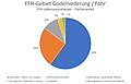
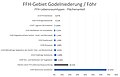
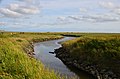
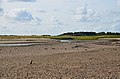
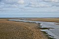
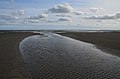
Area name: Godel lowland / Föhr
Type: Special Areas of Conservation
Area number: DE-1316-301
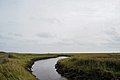
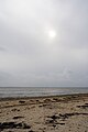
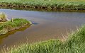
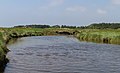
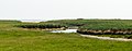
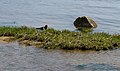
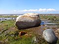
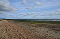
Description: On the south coast of the island of Föhr, the creeks Godel, Wiel and Luer brings salt water in the lowland unprotected by levee below the edge of the geest.
- It is a extended salt marsh landscape in lagoon location which is crossed by the stream Godel.
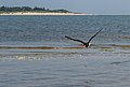
- The lowland area is an important bird breeding and resting area.
Place: Municipality Witsum, Collective municipality Föhr-Amrum, District Nordfriesland, Schleswig-Holstein, Germany
Media in category "FFH-Gebiet Godelniederung / Föhr"
The following 44 files are in this category, out of 44 total.
-
 001 2016 06 06 Voegel im Flug.jpg 2,692 × 2,228; 1.38 MB
-
 004 2016 06 11 Netze.jpg 3,333 × 1,500; 3.49 MB
-
 191009 Bach Godel bei Witsum mit Blickrichtung Nordwest.jpg 6,000 × 4,000; 7.25 MB
-
 191009 Bach Godel bei Witsum mit Blickrichtung Südost.jpg 6,000 × 4,000; 6.91 MB
-
 191009 Strand bei Witsum mit Blick Richtung Amrum.jpg 4,000 × 6,000; 5.92 MB
-
 FFH-Gebiet Godelniederung-Föhr-Eigentum.jpg 1,393 × 898; 78 KB
-
 FFH-Gebiet Godelniederung-Föhr-Gbu.jpg 1,365 × 903; 52 KB
-
 FFH-Gebiet Godelniederung-Föhr-LRK.jpg 1,392 × 897; 74 KB
-
 FFH-Gebiet Godelniederung-Föhr-LRT.jpg 1,393 × 899; 99 KB
-
 Föhr Godelniederung 001 2016 06 12.jpg 2,871 × 1,741; 4.22 MB
-
 Föhr Godelniederung 002 2016 06 06.jpg 1,773 × 2,818; 4.15 MB
-
 Föhr Godelniederung 003 2016 06 06.jpg 2,782 × 1,797; 4.72 MB
-
 Föhr Godelniederung 004 2016 06 06.jpg 1,860 × 2,686; 5.59 MB
-
 Föhr Godelniederung 005 2016 06 06.jpg 2,835 × 1,763; 5.32 MB
-
 Föhr Godelniederung 006 2016 06 06.jpg 3,045 × 1,641; 3.95 MB
-
 Föhr Godelniederung 007 2016 06 06.jpg 3,118 × 1,603; 4.41 MB
-
 Föhr Godelniederung 008 2016 06 06.jpg 2,871 × 1,741; 3.87 MB
-
 Föhr Godelniederung 009 2016 06 06.jpg 3,589 × 1,392; 4.09 MB
-
 Föhr Godelniederung 010 2016 06 06.jpg 2,938 × 1,701; 5.31 MB
-
 Föhr Godelniederung 011 2016 06 06.jpg 3,185 × 1,569; 4.3 MB
-
 Föhr Godelniederung 012 2016 06 06.jpg 2,825 × 1,769; 4.01 MB
-
 Föhr Godelniederung 013 2016 06 06.jpg 2,745 × 1,821; 3.93 MB
-
 Föhr Godelniederung 014 2016 06 06.jpg 2,815 × 1,776; 3.95 MB
-
 Föhr Godelniederung 015 2016 06 06.jpg 2,874 × 1,739; 5.45 MB
-
 Föhr Godelniederung 016 2016 06 06.jpg 1,788 × 2,795; 3.95 MB
-
 Föhr Godelniederung 017 2016 06 06.jpg 2,718 × 1,838; 3.41 MB
-
 Föhr Godelniederung 018 2016 06 06.jpg 2,731 × 1,830; 5.78 MB
-
 Föhr Godelniederung 019 2016 06 06.jpg 3,061 × 1,633; 4.06 MB
-
 Föhr Godelniederung 020 2016 06 06.jpg 2,910 × 1,717; 4.24 MB
-
 Klimawandel 003 2016 06 06.jpg 5,184 × 3,456; 8.52 MB
-
 Nationalpark Schleswig - Holsteinisches Wattenmeer - bei Föhr - steinig 01.jpg 2,592 × 1,944; 2.01 MB
-
 Nationalpark Schleswig - Holsteinisches Wattenmeer - bei Föhr - steinig 02.jpg 2,592 × 1,944; 1.45 MB
-
 Utersum-auf-Föhr Aug-2018 DSC 0371.JPG 4,928 × 3,264; 5.03 MB
-
 Witsum-auf-Föhr Aug-2018 DSC 0383.JPG 4,928 × 3,264; 6.54 MB
-
 Witsum-auf-Föhr Godel Aug-2018 02DSC0387.JPG 4,928 × 3,264; 5.94 MB
-
 Witsum-auf-Föhr Godel Aug-2018 03DSC0391.JPG 4,928 × 3,264; 7.05 MB
-
 Witsum-auf-Föhr Godel Aug-2018 04DSC0403.JPG 4,928 × 3,264; 7.82 MB
-
 Witsum-auf-Föhr Godel Aug-2018 05DSC0404.JPG 4,928 × 3,264; 6.88 MB
-
 Witsum-auf-Föhr Godel Aug-2018 06DSC0408.JPG 4,928 × 3,264; 6.22 MB
-
 Witsum-auf-Föhr Godel Aug-2018 07DSC0419.JPG 4,928 × 3,264; 6.48 MB
-
 Witsum-auf-Föhr Godel Aug-2018 08DSC0423.JPG 4,928 × 3,264; 5.21 MB
-
 Witsum-auf-Föhr Godel Aug-2018 09DSC0411.JPG 4,928 × 3,264; 6.97 MB
-
 Witsum-auf-Föhr Godel Aug-2018 10DSC0415.JPG 4,928 × 3,264; 6.13 MB
-
 Witsum-auf-Föhr Godel Aug-2018 11DSC0420.JPG 4,928 × 3,264; 5.03 MB


