Category:Friedenskirche (Waldsiedlung)
| Object location | | View all coordinates using: OpenStreetMap |
|---|
church  | |||||
| Upload media | |||||
| Instance of | |||||
|---|---|---|---|---|---|
| Named after | |||||
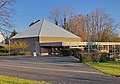
| Location | Leverkusen, Cologne Government Region, North Rhine-Westphalia, Germany | ||||
| Architectural style | |||||
 | |||||
Media in category "Friedenskirche (Waldsiedlung)"
The following 5 files are in this category, out of 5 total.
-
 Friedenskirche Leverkusen.jpg 3,859 × 2,252; 4.52 MB
-
 Schlebusch Evangelische Friedenskirche Glockenturm.jpg 1,373 × 4,631; 3.14 MB
-
 Schlebusch Evangelische Friedenskirche Innenraum.jpg 4,940 × 3,594; 9.55 MB
-
 Schlebusch Evangelische Friedenskirche Orgel.jpg 4,492 × 3,491; 9.1 MB
-
 Schlebusch Evangelische Friedenskirche.jpg 4,000 × 2,797; 5.21 MB


