Category:Geological maps of Nevada
States of the United States: Alabama · Alaska · Arizona · Arkansas · California · Colorado · Connecticut · Delaware · Florida · Georgia · Hawaii · Idaho · Illinois · Indiana · Iowa · Kansas · Kentucky · Louisiana · Maine · Maryland · Massachusetts · Michigan · Minnesota · Mississippi · Missouri · Montana · Nebraska · Nevada · New Hampshire · New Jersey · New Mexico · New York · North Carolina · North Dakota · Ohio · Oklahoma · Oregon · Pennsylvania · Rhode Island · South Carolina · South Dakota · Tennessee · Texas · Utah · Vermont · Virginia · Washington · West Virginia · Wisconsin · Wyoming
Puerto Rico
Puerto Rico
Subcategories
This category has the following 4 subcategories, out of 4 total.
*
M
- Mining maps of Nevada (2 F)
Media in category "Geological maps of Nevada"
The following 27 files are in this category, out of 27 total.
-
 Columbia River Flood-Basalt Province.jpg 1,224 × 1,237; 1.48 MB
-
 CRB-Yellowstone mantle plume model.jpg 3,789 × 4,069; 1.84 MB
-
 Digital-elevation-map-nevada.gif 917 × 1,320; 267 KB
-
 Ely Geology Part 1.PNG 749 × 609; 190 KB
-
 Ely Geology Part 2.PNG 729 × 610; 170 KB
-
 Geologic Map of Nevada 1978.jpg 13,800 × 20,100; 29.7 MB
-
 Geologic map of the Nevada Test Site - Atomic Testing Museum, Las Vegas 16.jpg 3,264 × 4,912; 5.31 MB
-

-
 Grouse Creek Block Location.jpg 563 × 523; 185 KB
-
 Grouse Creek block location1.jpg 1,131 × 1,206; 565 KB
-
 Lake Manly system.gif 1,160 × 1,260; 207 KB
-
 Lake Manly system.png 290 × 315; 16 KB
-
 Mesquite Nevada Geologic Map.gif 1,977 × 2,534; 973 KB
-
 Newberry-Yellowstone tracks.png 536 × 326; 19 KB
-
 NPS great-basin-geologic-map.jpg 2,389 × 3,806; 2.07 MB
-
 NPS lake-mead-geologic-map.jpg 4,760 × 3,055; 5.22 MB
-
 NVMap-doton-ToiyabeMtns.png 165 × 215; 1 KB
-
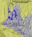 Pleistocene Lakes and Rivers of Mojave.png 545 × 631; 142 KB
-
 Railroad Valley Mineral Resources Map.png 1,905 × 1,611; 997 KB
-
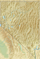 Relief map of U.S., Nevada.png 882 × 1,297; 1.12 MB
-
 Sedimentary-rock hosted gold deposits in Nevada.gif 518 × 594; 23 KB
-
 Soil survey of northwest Elko County area, Nevada - parts of Elko and Eureka Counties (IA soilsurveyofnort00bowe).pdf 2,304 × 2,777, 285 pages; 228.6 MB
-
 USGS - Benton Springs fault system.gif 214 × 218; 17 KB
-
 USGS McDermitt caldera geologic map.png 456 × 519; 46 KB
-
 USGS – Honey Lake fault zone.gif 214 × 218; 17 KB
-
 USGS – Pyramid Lake fault zone.gif 214 × 218; 17 KB
-
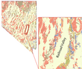
 YeringtonBatholith geologicmap.png 645 × 756; 616 KB


