Category:Gierstraat 52, Haarlem
| Object location | | View all coordinates using: OpenStreetMap |
|---|
 | |||||
| Upload media | |||||
| Instance of |
| ||||
|---|---|---|---|---|---|
| Location | Haarlem, North Holland, Netherlands | ||||
| Street address |
| ||||
| Located on street | |||||
| Heritage designation |
| ||||
 | |||||
|
This is a category about rijksmonument number 19171
|
| Address |
|
Media in category "Gierstraat 52, Haarlem"
The following 3 files are in this category, out of 3 total.
-
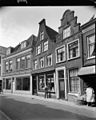 Gevels - Haarlem - 20097005 - RCE.jpg 959 × 1,200; 219 KB
-
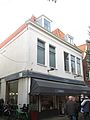 Haarlem - Gierstraat 52-54.jpg 1,944 × 2,592; 1,009 KB
-
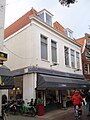 WLM-Haarlem 112.JPG 2,736 × 3,648; 1.95 MB

