Category:Hadley and Leegomery
civil parish in Telford and Wrekin, Shropshire, England | |||||
| Upload media | |||||
| Instance of | |||||
|---|---|---|---|---|---|
| Location | Telford and Wrekin, Shropshire, West Midlands, England | ||||
| Population |
| ||||
 | |||||
Subcategories
This category has the following 4 subcategories, out of 4 total.
Media in category "Hadley and Leegomery"
The following 69 files are in this category, out of 69 total.
-
 Apley House Site - geograph.org.uk - 1321376.jpg 640 × 480; 352 KB
-
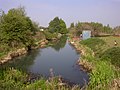
 Apley Pool - geograph.org.uk - 4280765.jpg 1,600 × 1,200; 244 KB
-

-
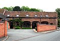
 Barns at Horton Farm - geograph.org.uk - 3513559.jpg 1,142 × 857; 353 KB
-

-
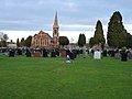 Cemetery and Chapel of Rest on Hadley Park Road - geograph.org.uk - 2739885.jpg 1,306 × 979; 331 KB
-
 Chapel Cottage, Horton - geograph.org.uk - 3513505.jpg 1,142 × 857; 431 KB
-
 Chapel Row, Horton - geograph.org.uk - 3513515.jpg 1,142 × 857; 404 KB
-
 Converted barn at Apley Castle - geograph.org.uk - 5403685.jpg 1,632 × 1,224; 830 KB
-
 Cul-de-sac near the Gurdwara - geograph.org.uk - 995689.jpg 640 × 480; 96 KB
-
 Cycle way and path - geograph.org.uk - 4074722.jpg 640 × 480; 128 KB
-
 Denso factory - Hortonwood - geograph.org.uk - 3068209.jpg 1,142 × 857; 323 KB
-
 Development site at Hortonwood, Telford. - geograph.org.uk - 4843319.jpg 3,091 × 2,048; 1.4 MB
-
 Entrance to the icehouse at Apley Castle - geograph.org.uk - 5404347.jpg 1,958 × 1,469; 1.65 MB
-
 Estate Building Conversion - geograph.org.uk - 1321403.jpg 640 × 476; 247 KB
-
 Except For Access - geograph.org.uk - 827111.jpg 640 × 480; 82 KB
-
 Factories on Queensway Business Park - geograph.org.uk - 3068224.jpg 1,142 × 857; 261 KB
-
 Factory at Hortonwood - geograph.org.uk - 832354.jpg 640 × 480; 79 KB
-
 Footbridge over the A5223 - geograph.org.uk - 3069589.jpg 979 × 734; 322 KB
-
 For Sale at Trench Lock - geograph.org.uk - 995692.jpg 640 × 480; 60 KB
-
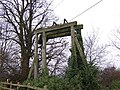 Guillotine Locks - geograph.org.uk - 117471 (cropped).jpg 568 × 426; 130 KB
-
 Guillotine Locks - geograph.org.uk - 117471.jpg 640 × 480; 166 KB
-
 Hadley Methodist Church - geograph.org.uk - 2738773.jpg 1,306 × 979; 363 KB
-
 Hadley Methodist Church - geograph.org.uk - 793668.jpg 640 × 433; 149 KB
-
 Hadley Park "Castle" - geograph.org.uk - 438077.jpg 640 × 480; 107 KB
-
 Horton Farm - Long Gone - geograph.org.uk - 816489.jpg 640 × 480; 64 KB
-
 Horton Lane (2) - geograph.org.uk - 827062.jpg 640 × 480; 109 KB
-
 Horton Lane - geograph.org.uk - 816378.jpg 480 × 640; 121 KB
-

-
 Interior of the icehouse - geograph.org.uk - 5404351.jpg 1,224 × 1,632; 616 KB
-
 Kingfisher Way, Apley, Wellington - geograph.org.uk - 3696321.jpg 800 × 614; 122 KB
-
 Kitchen Garden Wall, Apley Castle.jpg 1,632 × 1,224; 1.14 MB
-
 Manor Heights, Hadley - geograph.org.uk - 2738780.jpg 979 × 1,306; 271 KB
-
 Old lane through to Leegomery - geograph.org.uk - 4721010.jpg 857 × 1,142; 606 KB
-
 Only for fast readers - geograph.org.uk - 821130.jpg 640 × 480; 68 KB
-
 OS benchmark - Hadley, 26 Hadley Park Road - geograph.org.uk - 5065805.jpg 857 × 1,142; 527 KB
-
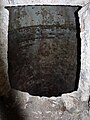
 OS benchmark - Hadley, 60 Castle Street - geograph.org.uk - 5065820.jpg 857 × 1,142; 423 KB
-
 OS benchmark - Hadley, Methodist Church - geograph.org.uk - 5065818.jpg 857 × 1,142; 548 KB
-

-
 OS benchmark - Leegomery, 1 Acacia Drive - geograph.org.uk - 4721033.jpg 857 × 1,142; 454 KB
-
-

-
 OS rivet - Leegomery, Grainger Drive underpass - geograph.org.uk - 4720992.jpg 857 × 1,142; 600 KB
-
 OS rivet - Leegomery, Pool Farm Drive bridge - geograph.org.uk - 4721092.jpg 857 × 1,142; 510 KB
-
 Outbuildings to Des-Res - geograph.org.uk - 1321456.jpg 640 × 442; 281 KB
-
 Princess Royal Hospital, Telford, car park - geograph.org.uk - 4598818.jpg 3,257 × 2,107; 1.9 MB
-
 Railway line - geograph.org.uk - 4074714.jpg 640 × 480; 114 KB
-
 Remains of the Telford Canal - geograph.org.uk - 2375211.jpg 2,592 × 1,944; 2.36 MB
-
 Section of former kitchen garden wall - geograph.org.uk - 5403681.jpg 1,632 × 1,224; 1.14 MB
-
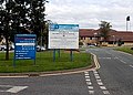
 Severn Hospice, Telford - geograph.org.uk - 1321449.jpg 640 × 406; 198 KB
-
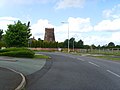
 Shawbirch island - geograph.org.uk - 3069275.jpg 1,215 × 862; 279 KB
-

-
 Strange Sculpture - geograph.org.uk - 1321428.jpg 640 × 480; 437 KB
-
 Summer House, now a bath showroom - geograph.org.uk - 4074729.jpg 640 × 480; 73 KB
-

-
 The A442 near Hadley Park - geograph.org.uk - 3068222.jpg 1,142 × 857; 277 KB
-
 The A442 Queensway north of Leegomery - geograph.org.uk - 3068228.jpg 1,142 × 857; 239 KB
-

-
 The Crow Brook - geograph.org.uk - 3513563.jpg 734 × 979; 448 KB
-
 The Hadley Learning Community ^ school - geograph.org.uk - 2738702.jpg 1,306 × 979; 316 KB
-
 The Kings Head, Hadley - geograph.org.uk - 2738775.jpg 1,142 × 857; 320 KB
-
 The NE corner of Apley Pool - geograph.org.uk - 2974765.jpg 1,077 × 808; 331 KB
-
 The old garden walls at Apley Castle - geograph.org.uk - 5403662.jpg 1,632 × 1,224; 905 KB
-
 The old Methodist Chapel - geograph.org.uk - 3513512.jpg 1,142 × 857; 461 KB
-
 The Old Mill, Hadley Castle - geograph.org.uk - 1285312.jpg 531 × 640; 258 KB
-
 Welcome to Horton - geograph.org.uk - 3513501.jpg 1,142 × 857; 485 KB
-
-
 Western boundary of Apley, Wellington - geograph.org.uk - 3696316.jpg 800 × 539; 149 KB
-
 White Row - geograph.org.uk - 3513552.jpg 1,142 × 857; 358 KB


.jpg)


_-_geograph.org.uk_-_827062.jpg)


_-_geograph.org.uk_-_5050365.jpg)


