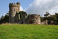
Category:Hagley Park Castle
This is a category about listed building number 1348597. |
| Object location | | View all coordinates using: OpenStreetMap |
|---|
folly in Hagley, Worcestershire, England, UK .jpg) | |||||
| Upload media | |||||
| Instance of | |||||
|---|---|---|---|---|---|
| Location | Hagley, Bromsgrove District, Worcestershire, West Midlands, England | ||||
| Heritage designation |
| ||||
 | |||||
Media in category "Hagley Park Castle"
The following 12 files are in this category, out of 12 total.
-
 Castle in Hagley Park (geograph 4185242).jpg 800 × 531; 125 KB
-
 Castle in Hagley Park - geograph-2103276.jpg 600 × 800; 250 KB
-
 Castle in Hagley Park - geograph.org.uk - 4185239.jpg 680 × 1,024; 262 KB
-
 Castle in Hagley Park - geograph.org.uk - 4185245.jpg 531 × 800; 144 KB
-
 Castle in Hagley Park - geograph.org.uk - 4185261.jpg 1,024 × 680; 271 KB
-
 Folly Drive - geograph.org.uk - 2648839.jpg 600 × 800; 149 KB
-
 Hagley Castle (5676993884).jpg 2,912 × 2,288; 3.48 MB
-
 Hagley Castle (geograph 2291664).jpg 640 × 480; 89 KB
-
 Hagley Castle 1 (3155760521).jpg 3,168 × 3,060; 5.28 MB
-
 Hagley Castle 2nd Jan (3159407785).jpg 4,752 × 3,168; 10.86 MB
-
 Hagley Castle 3 (3155751211).jpg 4,560 × 3,054; 7.02 MB
-
 Hagley Castle in the snow (3258810514).jpg 4,752 × 3,168; 7.9 MB
.jpg)


.jpg)
.jpg)
.jpg)
.jpg)
.jpg)