Category:Herkules-Hochhaus (Köln)
| Object location | | View all coordinates using: OpenStreetMap |
|---|

tower block  | |||||
| Upload media | |||||
| Instance of | |||||
|---|---|---|---|---|---|
| Location | Ehrenfeld, Cologne, Cologne Government Region, North Rhine-Westphalia, Germany | ||||
| Architect | |||||
| Height |
| ||||
 | |||||
Media in category "Herkules-Hochhaus (Köln)"
The following 13 files are in this category, out of 13 total.
-
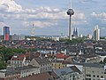
 201207241502-1345-Koeln-Colonius-Herkules.jpg 2,304 × 3,456; 3.71 MB
-
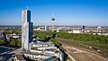 2020-04-21-Mediapark Drohne-0513.jpg 5,463 × 3,073; 12.21 MB
-
 2020-04-21-Mediapark Drone-002.jpg 4,581 × 5,665; 20.49 MB
-
 2020-04-21-Mediapark Drone-0466.jpg 3,628 × 3,628; 11.99 MB
-
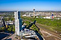 2020-04-21-Mediapark Drone-0508.jpg 5,231 × 3,485; 12.96 MB
-
 2020-04-21-Mediapark Drone-0521.jpg 5,464 × 3,640; 12.4 MB
-
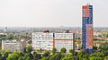
 2020-04-25-Herkuleshochhaus-0686.jpg 5,464 × 3,640; 14.44 MB
-
 2020-09-09-Pressefototermin Köln 5G-0175.jpg 3,787 × 5,681; 15.06 MB
-

-
 Herkules-Hochhaus, Zubringer zur A 57 in Köln-Ehrenfeld-0624.jpg 5,349 × 3,009; 11.4 MB
-
 Herkulesbuilding.jpg 1,944 × 2,592; 1.75 MB
-
 Koelnehrenfeld.jpg 2,592 × 1,944; 7.08 MB
-
 Wohnhochhäuser Graeffstraße 3 und 5, Herkules-Hochhaus-0628.jpg 3,691 × 2,076; 4.8 MB


