Category:Hermsdorf (bei Ruhland)
municipality in Brandenburg, Germany  Vesnický kostel  | |||||
| Upload media | |||||
| Instance of |
| ||||
|---|---|---|---|---|---|
| Location | Oberspreewald-Lausitz District, Brandenburg, Germany | ||||
| Population |
| ||||
| Area |
| ||||
| Elevation above sea level |
| ||||
| Different from | |||||
| official website | |||||
 | |||||
Subcategories
This category has the following 13 subcategories, out of 13 total.
J
L
Media in category "Hermsdorf (bei Ruhland)"
The following 17 files are in this category, out of 17 total.
-
De-Hermsdorf.ogg 1.6 s; 17 KB
-
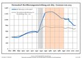 Bevölkerungsentwicklung Hermsdorf (bei Ruhland).pdf 1,752 × 1,239; 120 KB
-

-

-

-

-

-

-

-

-
 Hermsdorf (Oberlausitz), landscape.jpg 2,551 × 1,701; 1.33 MB
-
 Hermsdorf (Łużyce) (1).jpg 4,608 × 3,456; 4.54 MB
-
 Hermsdorf (Łużyce) (2).jpg 4,608 × 3,456; 3.98 MB
-
 Hermsdorf (Łużyce) (3).jpg 4,608 × 3,456; 3.58 MB
-
 Hermsdorf in OSL.svg 2,813 × 2,813; 765 KB
-
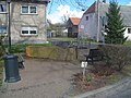 Hermsdorf Wassertrog.jpg 3,264 × 2,448; 1.82 MB
-
 Straßen in Hermsdorf mit OT Jannowitz und GT Lipsa aus OSM.jpg 2,143 × 6,426; 1,024 KB
,_Abfluss_des_Sch%C3%B6rlteichs_in_den_Grenzgraben_Ruhland-Hermsdorf,_Fr%C3%BChsommer,_01.jpg)
,_Eichenweg_bei_Kreuzung_Hauptstra%C3%9Fe,_Stieleiche_mit_Wanderwegeschild,_Fr%C3%BChsommer_2023,_01.jpg)
,_Hauptstra%C3%9Fe_bei_Abzweig_Wiesenstra%C3%9Fe,_Dorfbrunnen_mit_NABU_Hinweistafel,_Fr%C3%BChsommer,_01.jpg)
,_Hauptstra%C3%9Fe_bei_Abzweig_Wiesenstra%C3%9Fe,_Dorfbrunnen,_Fr%C3%BChsommer,_01.jpg)
,_Langer_Teich,_Nordansicht_von_Alte_Guteborner_Stra%C3%9Fe_1a,_Fr%C3%BChsommer_2023,_01.jpg)
,_Langer_Teich,_Nordostansicht_von_Alte_Guteborner_Stra%C3%9Fe_1a,_Fr%C3%BChsommer_2023,_01.jpg)
,_Langer_Teich,_Nordwestansicht_von_Alte_Guteborner_Stra%C3%9Fe_1a,_Fr%C3%BChsommer_2023,_01.jpg)
,_Sch%C3%B6rlteich_beim_Abfluss_in_den_Grenzgraben_Ruhland-Hermsdorf,_Fr%C3%BChsommer,_01.jpg)
,_landscape.jpg)
_(1).jpg)
_(2).jpg)
_(3).jpg)
