Category:Hervormde kerk (Paasloo)
| Object location | | View all coordinates using: OpenStreetMap |
|---|
church building in Steenwijkerland, Netherlands  | |||||
| Upload media | |||||
| Instance of | |||||
|---|---|---|---|---|---|
| Location | Paasloo, Steenwijkerland, Overijssel, Netherlands | ||||
| Street address |
| ||||
| Heritage designation |
| ||||
| Inception |
| ||||
 | |||||
|
This is a category about rijksmonument number 39905
|
| Address |
|
Media in category "Hervormde kerk (Paasloo)"
The following 33 files are in this category, out of 33 total.
-
 20140416 Kerk van Paasloo.jpg 4,896 × 3,672; 4.37 MB
-
 Exterieur naar het noord-westen - Paasloo - 20181440 - RCE.jpg 1,200 × 957; 301 KB
-
 Exterieur naar het noord-westen - Paasloo - 20181441 - RCE.jpg 1,200 × 954; 301 KB
-
 Exterieur naar het zuid-oosten - Paasloo - 20181438 - RCE.jpg 1,200 × 957; 262 KB
-
 Exterieur naar het zuid-oosten - Paasloo - 20181439 - RCE.jpg 1,200 × 955; 280 KB
-
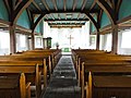 Interieur kerk van Paasloo.jpg 3,648 × 2,736; 470 KB
-
 Interieur naar het oosten - Paasloo - 20181444 - RCE.jpg 1,200 × 944; 186 KB
-
 Interieur naar het oosten - Paasloo - 20181445 - RCE.jpg 1,200 × 946; 169 KB
-
 Interieur naar het westen - Paasloo - 20181442 - RCE.jpg 1,200 × 955; 195 KB
-
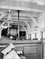
 Interieur, aanzicht orgel, orgelnummer 1127 - Paasloo - 20349122 - RCE.jpg 819 × 1,200; 156 KB
-
 Interieur, overzicht koor met altaar - Paasloo - 20350499 - RCE.jpg 1,172 × 1,200; 201 KB
-
 Interieur, overzicht naar het westen met orgel - Paasloo - 20350310 - RCE.jpg 1,176 × 1,200; 262 KB
-
 Inwendig naar het westen - Paasloo - 20181443 - RCE.jpg 912 × 1,200; 210 KB
-
 Kerk van Paasloo.jpg 3,648 × 2,736; 896 KB
-
 Monumentaal hek kerk van Paasloo.jpg 1,824 × 1,368; 452 KB
-
 Opbaarhuisje kerkhof Paaslo.jpg 2,736 × 3,648; 895 KB
-
 Overzicht noordoostgevel met kerkhof - Paasloo - 20350497 - RCE.jpg 1,172 × 1,200; 337 KB
-
 Overzicht noordwestgevel met kerkhof en baarhuisje - Paasloo - 20350493 - RCE.jpg 1,176 × 1,200; 362 KB
-
 Overzicht zuidoostgevel - Paasloo - 20350494 - RCE.jpg 1,176 × 1,200; 383 KB
-
 Overzicht zuidwestgevel met kerkhof - Paasloo - 20350487 - RCE.jpg 1,174 × 1,200; 372 KB
-
 Paasloo - Hervormde kerk -006.JPG 2,560 × 1,920; 2.07 MB
-
 Paasloo - Hervormde kerk -008.JPG 2,560 × 1,920; 1.45 MB
-
 Paasloo - Hervormde kerk -011.JPG 2,560 × 1,920; 1.8 MB
-
 Paasloo - Hervormde kerk -012.JPG 1,920 × 2,560; 1.6 MB
-
 Paasloo - Hervormde kerk -016.JPG 2,560 × 1,920; 1.99 MB
-
 Paasloo - Hervormde kerk -022.JPG 3,264 × 2,448; 2.89 MB
-
 Paasloo - Hervormde kerk -023.JPG 2,448 × 3,264; 2.76 MB
-
 Paasloo - Hervormde kerk -024.JPG 2,560 × 1,920; 2.3 MB
-
 Paasloo - Hervormde kerk -026.JPG 2,560 × 1,920; 2.45 MB
-
 Paasloo - Hervormde kerk -027.JPG 2,560 × 1,920; 2.23 MB
-
 Paasloo - Hervormde kerk -028.JPG 3,264 × 2,448; 3.5 MB
-
 Paasloo - Hervormde kerk -029.JPG 2,560 × 1,920; 2.19 MB
-
 Paasloo - Hervormde kerk -030.JPG 1,920 × 2,560; 2.26 MB


