Category:Holy Island Waggonway
C19 industrial transport system in Northumberland, England .jpg) .jpg) | |||||
| Upload media | |||||
| Instance of | |||||
|---|---|---|---|---|---|
| Location | Northumberland, North East England, England | ||||
| Date of official opening |
| ||||
| Date of official closure |
| ||||
 | |||||
Media in category "Holy Island Waggonway"
The following 21 files are in this category, out of 21 total.
-
 Bridge east of Lindisfarne Castle (geograph 2649237).jpg 640 × 425; 70 KB
-
 Earlier Holy Island Waggonway to a jetty on the SW of the island.png 778 × 1,242; 973 KB
-
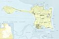 Holy Island (Overview).jpg 4,512 × 3,024; 7.21 MB
-
 Holy Island (stitched).jpg 292 × 534; 62 KB
-
 Holy Island eastern waggonway.png 679 × 650; 602 KB
-
 Holy Island Waggonway (stitched).jpg 1,412 × 3,166; 583 KB
-
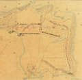 Holy Island Waggonway - John Higgins’ map of 1860.png 908 × 887; 1.63 MB
-
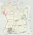 Holy Island waggonways.jpg 1,968 × 2,112; 2.37 MB
-
 Holy Island western waggonway.jpg 1,136 × 2,112; 1.46 MB
-
 Lime staithes near Holy Island Castle by Ralph Hedley.png 498 × 314; 309 KB
-
 Limestone pavement, Ness End (geograph 4686824).jpg 800 × 450; 353 KB
-

-
 North end of earlier Holy Island Waggonway to a jetty on the SW of the island.png 1,439 × 616; 1,015 KB
-
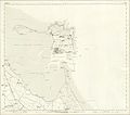
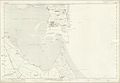 Northumberland Map Sheet IIX (including Elwick, Holy Island, Kyloe, Ross).jpg 8,176 × 5,680; 17.07 MB
-
 Northumberland Map Sheets VIII + IIX stitched (including Elwick, Holy Island, Kyloe, Ross).jpg 8,176 × 7,200; 27.35 MB
-

-
 The waggonway - geograph.org.uk - 996716.jpg 640 × 359; 79 KB
-
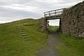
 Tramway Bridge, Lindisfarne Castle - geograph.org.uk - 1503160.jpg 683 × 1,024; 149 KB
-
 Waggonway and kilns (geograph 4686912).jpg 800 × 450; 334 KB
-

-
 ‘Unloading coal at a wood jetty – Holy Island’ by Ralph Hedley.png 237 × 311; 174 KB

.jpg)

.jpg)


.jpg)


.jpg)
.jpg)


.jpg)
.jpg)
