Category:Hull and Barnsley Railway
British pre-grouping railway company  | |||||
| Upload media | |||||
| Instance of | |||||
|---|---|---|---|---|---|
| Location |
| ||||
| Headquarters location | |||||
| Founded by |
| ||||
| Inception |
| ||||
| Date of official opening |
| ||||
| Followed by |
| ||||
| |||||
Subcategories
This category has the following 14 subcategories, out of 14 total.
B
C
D
- Drewton Tunnel (9 F)
F
H
R
- Riplingham Quarry (2 F)
S
- Sugar Loaf Tunnel (8 F)
W
- Weedley Tunnel (4 F)
Media in category "Hull and Barnsley Railway"
The following 66 files are in this category, out of 66 total.
-
 A railway came and went - geograph.org.uk - 1219802.jpg 640 × 480; 87 KB
-
 A walk from Hessle Square No17 (geograph 2006180).jpg 800 × 600; 213 KB
-
 A walk from Hessle Square No18 (geograph 2006188).jpg 800 × 600; 291 KB
-

-
 Approaching Little Weighton - geograph.org.uk - 757354.jpg 640 × 425; 104 KB
-
 Bankfield Lane - geograph.org.uk - 1257386.jpg 640 × 480; 73 KB
-
 Bridge over disused railway - geograph.org.uk - 1216182.jpg 640 × 480; 76 KB
-
 Bridge over the Old Railway - geograph.org.uk - 759441.jpg 640 × 425; 122 KB
-
 Bridleway-Farm Track - geograph.org.uk - 126622.jpg 640 × 480; 101 KB
-

-

-
 Communications Tower.JPG 1,024 × 768; 376 KB
-
 Crossing Farm (geograph 2636874).jpg 3,264 × 2,448; 1.61 MB
-
 Crossing Farm (geograph 3435982).jpg 3,986 × 2,222; 1.52 MB
-
 Dismantled Railway through fields (geograph 2636882).jpg 3,264 × 2,448; 2.22 MB
-
 Disused Railway Line near Everthorpe - geograph.org.uk - 173448.jpg 640 × 480; 105 KB
-
 Disused railway line near Shafton - geograph.org.uk - 1353628.jpg 640 × 480; 71 KB
-

-
 Disused railway line. - geograph.org.uk - 537351.jpg 640 × 433; 111 KB
-

-
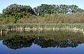 Eastrington Ponds Nature Reserve - geograph.org.uk - 592962.jpg 640 × 413; 108 KB
-
-
 Fallen Telegraph Pole - geograph.org.uk - 722795.jpg 640 × 480; 164 KB
-

-
 Footpath on the elevated stretch of old railway (geograph 6031216).jpg 1,024 × 768; 329 KB
-
 Former railway, Eastrington - geograph.org.uk - 1319559.jpg 640 × 426; 226 KB
-
 Green Oasis, Sculcoates - geograph.org.uk - 937935.jpg 640 × 425; 121 KB
-
 H&BRyCo Crest.jpg 537 × 574; 136 KB
-
 Hessle Road Junction - Hull.JPG 2,816 × 2,120; 1.49 MB
-
 Hull & Barnsley Swing Bridge.JPG 1,280 × 960; 489 KB
-
 Hull and Barnsley Goods wagon 3697.png 284 × 208; 155 KB
-
 Hull and Barnsley Goods wagon 577.png 344 × 255; 208 KB
-
 Kirk Smeaton railway station (site), Yorkshire (geograph 3531493).jpg 1,024 × 768; 255 KB
-
 Low Hunsley Plantation - geograph.org.uk - 962.jpg 640 × 480; 62 KB
-
 Low trees on a dead railway line, east of Little Smeaton (geograph 4281505).jpg 1,024 × 768; 138 KB
-
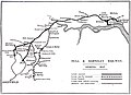 Map of Hull and Barnsley Railway 1920.jpg 2,880 × 2,096; 463 KB
-
 Near Little Weighton cutting 2.jpg 1,024 × 768; 367 KB
-
 Near Little Weighton cutting 3.jpg 1,024 × 768; 406 KB
-
 Near Little Weighton cutting 4.jpg 1,024 × 768; 447 KB
-
 Near Little Weighton cutting.jpg 1,024 × 768; 448 KB
-
 Near top edge of Little Weighton cutting.jpg 1,024 × 768; 505 KB
-
 North of Westfield Road - geograph.org.uk - 609568.jpg 640 × 434; 145 KB
-

-
 Oxen Stang Field, Barmby - geograph.org.uk - 576255.jpg 640 × 455; 72 KB
-
 Pedestrian underpass, Willerby - geograph.org.uk - 401391.jpg 456 × 640; 218 KB
-
 Remains of level crossing, Asselby (geograph 5407382).jpg 1,024 × 768; 176 KB
-
 Roadside Copse - geograph.org.uk - 926550.jpg 480 × 640; 189 KB
-
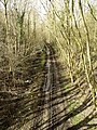
 Route of Old Railway - geograph.org.uk - 757098.jpg 425 × 640; 143 KB
-
 Sculcoates, Hull - geograph.org.uk - 1231350.jpg 640 × 481; 114 KB
-
 Sherwood Drive, Anlaby Common - geograph.org.uk - 563771.jpg 504 × 640; 151 KB
-
 Skelfleet Drain - geograph.org.uk - 752474.jpg 530 × 640; 187 KB
-

-
 Steps down to Gorton Road (geograph 6031220).jpg 1,024 × 768; 400 KB
-
 Steps up to the former railway line at Gorton Road (geograph 3743674).jpg 1,024 × 681; 389 KB
-
 The Hull and Barnsley Railway - geograph.org.uk - 511177.jpg 480 × 640; 157 KB
-
 The Hull and Barnsley Railway Company's Offices, Charlotte Street.jpg 500 × 369; 114 KB
-

-
-

-

-
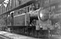
 Walton-on-the Hill Engine Shed geograph-2380624-by-Ben-Brooksbank.jpg 2,394 × 1,399; 884 KB
-
 Wath H&B railway station (site), Yorkshire (geograph 3789546).jpg 1,024 × 768; 187 KB
-
 Weedley Dale - geograph.org.uk - 829327.jpg 640 × 480; 119 KB
-

-

-
 Stubbs Bridge - geograph.org.uk - 220280.jpg 640 × 480; 144 KB

.jpg)
.jpg)


.jpg)
.jpg)
.jpg)


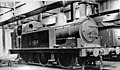
_0-6-2T_in_Springhead_Shed,_1947_-_geograph.org.uk_-_4801239.jpg)


.jpg)


,_Yorkshire_(geograph_3531493).jpg)

.jpg)


.jpg)


.jpg)
.jpg)


_-_geograph.org.uk_-_722888.jpg)


,_Yorkshire_(geograph_3789546).jpg)


