Category:Jüdischer Friedhof (Ibbenbüren)
| Object location | | View all coordinates using: OpenStreetMap |
|---|
 | |||||
| Upload media | |||||
| Instance of | |||||
|---|---|---|---|---|---|
| Location | Ibbenbüren, Steinfurt, Münster Government Region, North Rhine-Westphalia, Germany | ||||
| Heritage designation | |||||
 | |||||

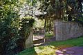
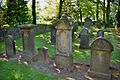
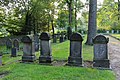
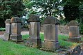
Deutsch: Der jüdische Friedhof in Ibbenbüren.
English: Jewish cemetery in Ibbenbüren, Germany.
Media in category "Jüdischer Friedhof (Ibbenbüren)"
The following 14 files are in this category, out of 14 total.
-
 Juedischer Friedhof Ibbenbueren 01.jpg 1,536 × 1,024; 1.54 MB
-
 Juedischer Friedhof Ibbenbueren 02.jpg 1,536 × 1,024; 1.64 MB
-
 Juedischer Friedhof Ibbenbueren 03.jpg 1,536 × 1,024; 1.65 MB
-
 Juedischer Friedhof Ibbenbueren 04.jpg 1,536 × 1,024; 1.51 MB
-
 Juedischer Friedhof Ibbenbueren 05.jpg 1,536 × 1,024; 1.55 MB
-
 Juedischer Friedhof Ibbenbueren 06.jpg 1,536 × 1,024; 1.55 MB
-
 Juedischer Friedhof Ibbenbueren 07.jpg 1,536 × 1,024; 1.41 MB
-
 Juedischer Friedhof Ibbenbueren 08.jpg 1,024 × 1,536; 1.59 MB
-
 Juedischer Friedhof Ibbenbueren 09.jpg 1,536 × 1,024; 1.54 MB
-
 Juedischer Friedhof Ibbenbueren 10.jpg 1,024 × 1,536; 1.44 MB
-
 Juedischer Friedhof Ibbenbueren 11.JPG 5,262 × 3,508; 18.92 MB
-
 Juedischer Friedhof Ibbenbueren 12.jpg 5,472 × 3,648; 15.15 MB
-
 Juedischer Friedhof Ibbenbueren 14.jpg 5,472 × 3,648; 13.16 MB
-
 Juedischer Friedhof Ibbenbueren Friedhofsmauer.jpg 1,536 × 1,024; 1.72 MB


