Category:Jagdhaus Dobra (Bad Liebenwerda)
| Object location | | View all coordinates using: OpenStreetMap |
|---|
This is the category of the Brandenburger Baudenkmal (cultural heritage monument) with the ID 09135366 (Wikidata)
|
 | |||||
| Upload media | |||||
| Instance of | |||||
|---|---|---|---|---|---|
| Location | Bad Liebenwerda, Elbe-Elster District, Brandenburg, Germany | ||||
| Heritage designation | |||||
 | |||||
Media in category "Jagdhaus Dobra (Bad Liebenwerda)"
The following 5 files are in this category, out of 5 total.
-
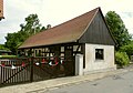 Jagdhaus Dobra Nebengebäude P1040406 b.jpg 4,462 × 3,136; 1.39 MB
-
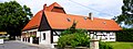 Jagdhaus Dobra P1040405 b.jpg 4,586 × 1,728; 1.64 MB
-
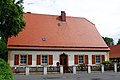 Jagdhaus Dobra P1040411.jpg 3,047 × 2,022; 784 KB
-
 Liebenwerdaer Heide bei Dobra P1040412.jpg 2,947 × 675; 235 KB
-
 Liebenwerdaer Heide bei Dobra P1040413.jpg 4,597 × 923; 887 KB
