Category:Johannes de Doperkerk (Den Burg)
| Object location | | View all coordinates using: OpenStreetMap |
|---|
_20200616.jpg) | |||||
| Upload media | |||||
| Instance of | |||||
|---|---|---|---|---|---|
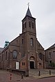
| Location | Texel, North Holland, Netherlands | ||||
| Street address |
| ||||
| Architectural style | |||||
| Architect | |||||
| Inception |
| ||||
| Religion or worldview | |||||
 | |||||
Nederlands: Kerk uit 1863 aan Molenstraat 36, 1791 DL Den Burg. Architect: Th. Molkenboer. Pastorie/woonhuis, Molenstraat 34a, Den Burg
Pastorie:
|
This is a category about a municipal monument in Texel with number GDB30 |
Gedenkraam:
|
This is a category about a war memorial in the Netherlands, number: 1022
|
Media in category "Johannes de Doperkerk (Den Burg)"
The following 13 files are in this category, out of 13 total.
-
 Interieur, aanzicht orgel, orgelnummer 321 - Den Burg - 20417117 - RCE.jpg 773 × 1,200; 136 KB
-
 Johannes de Doperkerk, Den Burg. Gedenkraam.jpg 2,432 × 2,343; 2.87 MB
-
 Johannes de Doperkerk, Den Burg. Interieur 01.jpg 4,320 × 2,432; 3.56 MB
-
 Johannes de Doperkerk, Den Burg. Interieur 02.jpg 4,200 × 2,432; 3.43 MB
-
 Johannes de Doperkerk, Den Burg. Kerkraam.jpg 1,751 × 1,600; 1.22 MB
-
 RK kerk - Den Burg - 1.jpg 3,480 × 4,640; 5.02 MB
-
 RK kerk - Den Burg - 2.jpg 3,480 × 4,640; 5.56 MB
-
 Texel - Den Burg - H. Johannes de Doperkerk (Molenstraat 36) 20200616 dagkapel.jpg 5,000 × 3,344; 3.32 MB
-
 Texel - Den Burg - H. Johannes de Doperkerk (Molenstraat 36) 20200616 doopkapel.jpg 2,212 × 3,000; 1.43 MB
-
 Texel - Den Burg - H. Johannes de Doperkerk (Molenstraat 36) 20200616 interieur.jpg 5,000 × 2,653; 2.71 MB
-
 Texel - Den Burg - H. Johannes de Doperkerk (Molenstraat 36) 20200616.jpg 3,265 × 4,900; 3.04 MB
-
 Zilveren kelk - Burg, Den (Texel) - 20045791 - RCE.jpg 859 × 1,200; 258 KB
-
 Zilveren monstrans - Burg, Den (Texel) - 20045792 - RCE.jpg 878 × 1,200; 246 KB


_20200616_dagkapel.jpg)
_20200616_doopkapel.jpg)
_20200616_interieur.jpg)
_-_20045791_-_RCE.jpg)
_-_20045792_-_RCE.jpg)