Category:Kanaalweg W.Z. 7, Veere
| Object location | | View all coordinates using: OpenStreetMap |
|---|
 | |||||
| Upload media | |||||
| Instance of |
| ||||
|---|---|---|---|---|---|
| Part of | |||||
| Location | Veere, Zeeland, Netherlands | ||||
| Street address |
| ||||
| Located on street |
| ||||
| Heritage designation |
| ||||
 | |||||
|
This is a category about rijksmonument number 507831
|
| Address |
|
Media in category "Kanaalweg W.Z. 7, Veere"
The following 3 files are in this category, out of 3 total.
-
 Overzicht linker zijgevel sluismeesterswoning - Veere - 20352640 - RCE.jpg 1,183 × 1,200; 464 KB
-
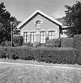 Overzicht voorgevel sluismeesterswoning - Veere - 20352639 - RCE.jpg 1,183 × 1,200; 423 KB
-
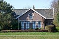 Veere Kanaalweg Westzijde 7.jpg 3,552 × 2,368; 2.01 MB

