Home
Random
Nearby
Log in
Settings
Donate
About Wikimedia Commons
Disclaimers
Search
Category
:
Kelleyville Bridge
Language
Watch
Edit
Media in category "Kelleyville Bridge"
The following 17 files are in this category, out of 17 total.
Crown detail looking northeast - Kelleyville Bridge, Spanning Sugar River at State Route11-103, Newport, Sullivan County, NH HAER NH,10-NEWP.V,1-17.tif
5,000 × 4,023; 19.19 MB
General view looking northeast - Kelleyville Bridge, Spanning Sugar River at State Route11-103, Newport, Sullivan County, NH HAER NH,10-NEWP.V,1-2.tif
5,000 × 4,027; 19.2 MB
General view looking west - Kelleyville Bridge, Spanning Sugar River at State Route11-103, Newport, Sullivan County, NH HAER NH,10-NEWP.V,1-1.tif
5,000 × 3,986; 19.01 MB
Approach span abutment and pier on east side looking southeast - Kelleyville Bridge, Spanning Sugar River at State Route11-103, Newport, Sullivan County, NH HAER NH,10-NEWP.V,1-13.tif
5,000 × 3,964; 18.9 MB
Approach span abutment and pier on west side looking west - Kelleyville Bridge, Spanning Sugar River at State Route11-103, Newport, Sullivan County, NH HAER NH,10-NEWP.V,1-14.tif
5,000 × 4,006; 19.1 MB
Approach span and former railroad right-of-way on west side looking northeast - Kelleyville Bridge, Spanning Sugar River at State Route11-103, Newport, Sullivan County, NH HAER NH,10-NEWP.V,1-7.tif
5,000 × 4,019; 19.17 MB
Approach span on east side looking southwest - Kelleyville Bridge, Spanning Sugar River at State Route11-103, Newport, Sullivan County, NH HAER NH,10-NEWP.V,1-8.tif
5,000 × 4,006; 19.1 MB
Approach span underside and pier at arch span abutment on west side looking southeast - Kelleyville Bridge, Spanning Sugar River at State Route11-103, Newport, Sullivan County, HAER NH,10-NEWP.V,1-15.tif
4,052 × 5,000; 19.32 MB
Arch ring and columns and repairs at west side looking south - Kelleyville Bridge, Spanning Sugar River at State Route11-103, Newport, Sullivan County, NH HAER NH,10-NEWP.V,1-16.tif
4,071 × 5,000; 19.41 MB
Arch span abutment and pier on east side looking east - Kelleyville Bridge, Spanning Sugar River at State Route11-103, Newport, Sullivan County, NH HAER NH,10-NEWP.V,1-11.tif
4,054 × 5,000; 19.33 MB
Arch span abutment and pier on west side looking north - Kelleyville Bridge, Spanning Sugar River at State Route11-103, Newport, Sullivan County, NH HAER NH,10-NEWP.V,1-12.tif
4,047 × 5,000; 19.3 MB
East approach to bridge and view of deck, looking northwest - Kelleyville Bridge, Spanning Sugar River at State Route11-103, Newport, Sullivan County, NH HAER NH,10-NEWP.V,1-4.tif
5,000 × 3,968; 18.92 MB
Northeast elevation looking southwest - Kelleyville Bridge, Spanning Sugar River at State Route11-103, Newport, Sullivan County, NH HAER NH,10-NEWP.V,1-5.tif
5,000 × 4,003; 19.09 MB
Southwest elevation looking northeast - Kelleyville Bridge, Spanning Sugar River at State Route11-103, Newport, Sullivan County, NH HAER NH,10-NEWP.V,1-6.tif
5,000 × 3,987; 19.01 MB
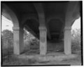
Underside looking northwest - Kelleyville Bridge, Spanning Sugar River at State Route11-103, Newport, Sullivan County, NH HAER NH,10-NEWP.V,1-10.tif
4,048 × 5,000; 19.31 MB
Underside looking southeast - Kelleyville Bridge, Spanning Sugar River at State Route11-103, Newport, Sullivan County, NH HAER NH,10-NEWP.V,1-9.tif
4,052 × 5,000; 19.32 MB
West approach to bridge and view of deck, looking southeast - Kelleyville Bridge, Spanning Sugar River at State Route11-103, Newport, Sullivan County, NH HAER NH,10-NEWP.V,1-3.tif
5,000 × 4,005; 19.1 MB