File:Approach span on east side looking southwest - Kelleyville Bridge, Spanning Sugar River at State Route11-103, Newport, Sullivan County, NH HAER NH,10-NEWP.V,1-8.tif

Size of this JPG preview of this TIF file: 748 × 599 pixels. Other resolutions: 300 × 240 pixels | 599 × 480 pixels | 959 × 768 pixels | 1,278 × 1,024 pixels | 2,556 × 2,048 pixels | 5,000 × 4,006 pixels.
Original file (5,000 × 4,006 pixels, file size: 19.1 MB, MIME type: image/tiff)
Captions
Captions
Add a one-line explanation of what this file represents
Summary edit
| Approach span on east side looking southwest - Kelleyville Bridge, Spanning Sugar River at State Route11-103, Newport, Sullivan County, NH | ||||
|---|---|---|---|---|
| Photographer |
Tucher, Rob |
|||
| Title |
Approach span on east side looking southwest - Kelleyville Bridge, Spanning Sugar River at State Route11-103, Newport, Sullivan County, NH |
|||
| Depicted place | New Hampshire; Sullivan County; Newport | |||
| Date | 1995 | |||
| Dimensions | height: 4 in (10.1 cm); width: 5 in (12.7 cm) | |||
| Current location |
Library of Congress Prints and Photographs Division Washington, D.C. 20540 USA http://hdl.loc.gov/loc.pnp/pp.print |
|||
| Accession number |
HAER NH,10-NEWP.V,1-8 |
|||
| Credit line |
|
|||
| Notes |
|
|||
| Source | https://www.loc.gov/pictures/item/nh0260.photos.346535p | |||
| Permission (Reusing this file) |
|
|||

| Object location | | View this and other nearby images on: OpenStreetMap |
|---|
File history
Click on a date/time to view the file as it appeared at that time.
| Date/Time | Thumbnail | Dimensions | User | Comment | |
|---|---|---|---|---|---|
| current | 06:14, 29 July 2014 | 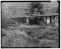 | 5,000 × 4,006 (19.1 MB) | Fæ (talk | contribs) | GWToolset: Creating mediafile for Fæ. HABS 24 July 2014 (2001:2300) |
You cannot overwrite this file.
File usage on Commons
The following page uses this file: