Category:Keseburg
| Object location | | View all coordinates using: OpenStreetMap |
|---|
_(0002).JPG) | |||||
| Upload media | |||||
| Instance of | |||||
|---|---|---|---|---|---|
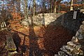
| Location | Ederbringhausen, Vöhl, Waldeck-Frankenberg, Kassel Government Region, Hesse, Germany | ||||
| Heritage designation | |||||
 | |||||
This is the category of the Hessian Kulturdenkmal (cultural monument) with the ID 79723 (Wikidata)
|
Media in category "Keseburg"
The following 9 files are in this category, out of 9 total.
-
 Keseburg (0003).JPG 5,184 × 3,456; 10.92 MB
-
 Keseburg (0004).JPG 5,184 × 3,456; 12.19 MB
-
 Keseburg (0005).JPG 5,184 × 3,456; 10.15 MB
-
 Keseburg (0006).JPG 5,184 × 3,456; 12.47 MB
-
 Keseburg (0007).JPG 5,184 × 3,456; 10.15 MB
-
 Keseburg (0008).JPG 5,184 × 3,456; 10.69 MB
-
 Keseburg (Kellerwald) (0001).JPG 3,456 × 5,184; 6.46 MB
-
 Keseburg (Kellerwald) (0002).JPG 5,184 × 3,456; 11.8 MB
-
 Keseburg.jpg 537 × 787; 234 KB
.JPG)
.JPG)
.JPG)
.JPG)
.JPG)
.JPG)
_(0001).JPG)
