Category:Kirchenruine (Arendsee, Nordwestuckermark)
| Object location | | View all coordinates using: OpenStreetMap |
|---|
This is the category of the Brandenburger Baudenkmal (cultural heritage monument) with the ID 09130010 (Wikidata)
|
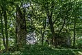
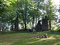
English: Pictures of the church ruin in Arendsee, Nordwestuckermark municipality, Uckermark district, Brandenburg state, Germany
Deutsch: Bilder der Kirchenruine in Arendsee, Gemeinde Nordwestuckermark, Landkreis Uckermark, Land Brandenburg, Deutschland.
Français : Photos de la ruine de l'église à Arendsee, commune de Nordwestuckermark, arrondissement de Uckermark, état fédéral de Brandebourg, Allemagne
| Upload media | |||||
| Instance of | |||||
|---|---|---|---|---|---|
| Location | Nordwestuckermark, Uckermark District, Brandenburg, Germany | ||||
| Heritage designation | |||||
 | |||||
Media in category "Kirchenruine (Arendsee, Nordwestuckermark)"
The following 4 files are in this category, out of 4 total.
-
 Arendsee 05 18 03 jiw.jpg 1,920 × 1,280; 1.1 MB
-
 Arendsee Ruine 2.jpg 3,000 × 4,000; 4.77 MB
-
 Arendsee Ruine 3.JPG 4,000 × 3,000; 4.59 MB
-
 Arendsee Ruine1.JPG 4,000 × 3,000; 4.88 MB


