Category:Klif 23, Den Hoorn (Texel)
| Object location | | View all coordinates using: OpenStreetMap |
|---|
 | |||||
| Upload media | |||||
| Instance of | |||||
|---|---|---|---|---|---|
| Location | Den Hoorn, North Holland, Texel, North Holland, Netherlands | ||||
| Street address |
| ||||
| Located on street | |||||
| Heritage designation |
| ||||
 | |||||
|
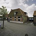
This is a category about rijksmonument number 35236
|
Nederlands: Voormalige boerderij - anno 1810 - Eethuis
| Address |
|
Media in category "Klif 23, Den Hoorn (Texel)"
The following 3 files are in this category, out of 3 total.
-
 Den Hoorn - Klif 23.jpg 2,592 × 1,944; 1.53 MB
-
 Rechter zijgevel gezien vanaf straatkant - Den Hoorn - 20396310 - RCE.jpg 1,200 × 1,200; 309 KB
-
 Voorgevel en rechter zijgevel - Den Hoorn - 20396309 - RCE.jpg 1,200 × 1,200; 285 KB

