Category:Kraftwerk Harkort
| Object location | | View all coordinates using: OpenStreetMap |
|---|
This is the category for an architectural monument.
It is on the list of cultural monuments of Wetter (Ruhr), no. 117.
It is on the list of cultural monuments of Wetter (Ruhr), no. 117.
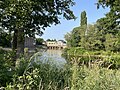
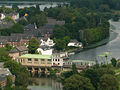
run-of-the-river power station in Alt-Wetter, Germany  | |||||
| Upload media | |||||
| Instance of | |||||
|---|---|---|---|---|---|
| Part of | |||||
| Location | Alt-Wetter, Wetter, Ennepe-Ruhr-Kreis, Arnsberg Government Region, North Rhine-Westphalia, Germany | ||||
| Located in or next to body of water | |||||
| Owned by | |||||
| Operator | |||||
| Heritage designation | |||||
| Nominal power capacity |
| ||||
| Elevation above sea level |
| ||||
 | |||||
Media in category "Kraftwerk Harkort"
The following 5 files are in this category, out of 5 total.
-
 1908 Firma Harkort & Sohn.jpg 1,642 × 1,122; 563 KB
-
 2021 Kraftwerk Harkort.png 1,471 × 760; 2.27 MB
-
 Wetter Kraftwerk1.jpg 4,032 × 3,024; 5.67 MB
-
 Wetter Kraftwerk2.jpg 4,032 × 3,024; 3.02 MB
-
 WetterKraftwerkHarkort.jpg 640 × 480; 89 KB


