Category:Kreis Lübbecke
| Object location | | View all coordinates using: OpenStreetMap |
|---|
former district of North Rhine-Westphalia   | |||||
| Upload media | |||||
| Instance of | |||||
|---|---|---|---|---|---|
| Location | Detmold Government Region, North Rhine-Westphalia, Germany | ||||
| Capital | |||||
| Inception |
| ||||
| Dissolved, abolished or demolished date |
| ||||
| Area |
| ||||
 | |||||
Deutsch: Der Kreis Lübbecke (1816–1832: Kreis Rahden; 1939–1969: Landkreis Lübbecke) war ein von 1816 bis 1972 bestehender Kreis.
Subcategories
This category has the following 4 subcategories, out of 4 total.
Media in category "Kreis Lübbecke"
The following 13 files are in this category, out of 13 total.
-
 Falk Oberdorf Altkreis Lübbecke Gliederung.PNG 916 × 938; 66 KB
-
 Falk Oberdorf Bodenutzung Altkreis Lübbecke absolut.png 768 × 558; 26 KB
-
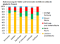 Falk Oberdorf Bodenutzung Altkreis Lübbecke relativ.png 768 × 562; 27 KB
-
 Falk Oberdorf Dichte Kreis LK neu.PNG 989 × 948; 61 KB
-
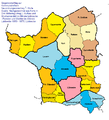 Falk Oberdorf Gliederung Kreis Lübbecke 1.Stufe.png 911 × 1,001; 59 KB
-
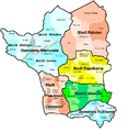
 Falk Oberdorf Gliederung Kreis Lübbecke.png 1,052 × 924; 52 KB
-
 Falk Oberdorf Kreis LK 1897 neu3.png 780 × 832; 229 KB
-
 Falk Oberdorf LK Kennzeichen 1972.png 950 × 938; 1.68 MB
-
 Falk Oberdorf Variante 1 Kreisneugliederung.png 770 × 808; 34 KB
-
 Falk Oberdorf Variante 3 Kreisneugliederung.png 767 × 851; 31 KB
-
 Falk Oberdorf Variante 4 Kreisneugliederung.png 770 × 826; 32 KB
-
 Falk Oberdorf Variante 5 Kreisneugliederung.png 767 × 745; 27 KB
-
 Börninghausen Mai 2009 180.jpg 1,200 × 1,600; 803 KB


