Category:Labelled administrative maps of France
Media in category "Labelled administrative maps of France"
The following 15 files are in this category, out of 15 total.
-
 1789 + 2022 Auvergne-Rhône-Alpes, noms.png 1,416 × 1,209; 206 KB
-
 1789 + 2022 Bourgogne-Franche-Comté, noms.png 1,451 × 1,290; 222 KB
-
 1789 + 2022 Bretagne, noms.png 1,135 × 873; 101 KB
-
 1789 + 2022 France, noms des régions.png 4,264 × 4,098; 1.34 MB
-
 1789 + 2022 Grand Est, noms.png 1,583 × 1,125; 210 KB
-
 1789 + 2022 Hauts-de-France + Île, noms.png 866 × 1,378; 136 KB
-
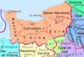 1789 + 2022 Normandie, noms.png 1,228 × 836; 117 KB
-
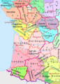 1789 + 2022 Nouvelle Aquitaine, noms.png 1,361 × 1,895; 277 KB
-
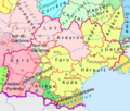 1789 + 2022 Occitanie, noms.png 1,483 × 1,260; 204 KB
-
 1789 + 2022 Pays de la Loire, noms.png 1,130 × 1,134; 150 KB
-
 1789 + 2022 Provence, noms.png 984 × 914; 100 KB
-
 1789 + 2022 Île-de-France216.png 2,025 × 1,554; 595 KB
-
 1789 et 2022, Centre-Val de Loire et Île-de-France, noms.png 1,200 × 1,368; 188 KB
-
 2022 France - régions et départements, noms hu.png 1,842 × 1,696; 1.11 MB
-
 2022 France - régions et départements, noms.png 1,842 × 1,696; 619 KB


