Category:Lindenbrunnen (Bern)
| Object location | | View all coordinates using: OpenStreetMap |
|---|
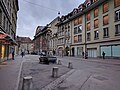
Deutsch: Der Lindenbrunnen ist ein Brunnen mit einem Nebenbrunnen von 1840/1899 vor dem Gebäude Zeughausgasse 14 in der Altstadt von Bern in der Schweiz.
alley fountain with basin, floor with rocaille vase and side trough  | |||||
| Upload media | |||||
| Instance of |
| ||||
|---|---|---|---|---|---|
| Part of | |||||
| Made from material | |||||
| Genre | |||||
| Location | Zeughausgasse, Yellow Quarter, Inner City, Bern, Bern-Mittelland administrative district, Bernese Mittelland administrative region, Bern, Switzerland | ||||
| Street address |
| ||||
| Located on street |
| ||||
| Owned by | |||||
| Operator | |||||
| Inception |
| ||||
| Elevation above sea level |
| ||||
 | |||||
Media in category "Lindenbrunnen (Bern)"
The following 6 files are in this category, out of 6 total.
-
 Gelbes Quartier, Bern, Switzerland - panoramio (18).jpg 3,648 × 2,736; 771 KB
-
 Gelbes Quartier, Bern, Switzerland - panoramio (25).jpg 3,648 × 2,736; 758 KB
-
 Gelbes Quartier, Bern, Switzerland - panoramio (26).jpg 3,648 × 2,736; 798 KB
-
 Lindenbrunnen 01.jpg 2,895 × 4,350; 8 MB
-
 Lindenbrunnen 02.jpg 3,056 × 4,592; 7.44 MB
-
 Zeughausgasse.jpg 4,032 × 3,024; 4.31 MB
.jpg)
.jpg)
.jpg)

