Category:London N17

Subcategories
This category has the following 7 subcategories, out of 7 total.
B
D
L
M
Media in category "London N17"
The following 174 files are in this category, out of 174 total.
-
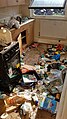
 Haringey Council flat effectively institutional neglect 06.jpg 2,268 × 4,032; 7 MB
-
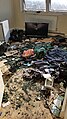
 Haringey Council flat effectively institutional neglect 07.jpg 2,268 × 4,032; 8.82 MB
-
 Haringey Council flat effectively institutional neglect 08.jpg 1,799 × 2,699; 3.51 MB
-
 Haringey Council flat effectively institutional neglect 09.jpg 2,268 × 4,032; 6.91 MB
-
 Haringey Council flat effectively institutional neglect 10.jpg 2,268 × 4,032; 7.67 MB
-
 Haringey Council flat effectively institutional neglect 11.jpg 4,032 × 2,268; 8.29 MB
-
 Haringey Council flat effectively institutional neglect 12.jpg 2,268 × 4,032; 10.19 MB
-
 20 to 24 Lordship Lane N17.jpg 1,930 × 1,348; 399 KB
-
 Brassica oleracea Cabbage display in Tottenham London England.jpg 4,613 × 2,595; 6.09 MB
-
 Boxes of green grocery on The Roundway Tottenham London England.jpg 4,608 × 3,456; 7.97 MB
-
 Boxes of green grocery, Lordship Lane, Tottenham, London, England.jpg 5,184 × 2,916; 11.97 MB
-
 Corner shop mushrooms in Haringey, London, England.jpg 1,681 × 1,121; 1.07 MB
-
 Building construction at Tottenham Hale, Haringey 1.jpg 2,526 × 3,789; 5.44 MB
-
 Crane at Tottenham Hale, Haringey 1.jpg 2,049 × 3,644; 3.67 MB
-
 Building construction at Tottenham Hale, Haringey 2.jpg 3,024 × 4,032; 7.7 MB
-
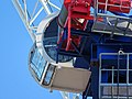 Crane at Tottenham Hale, Haringey 2 cabin.jpg 4,608 × 3,456; 10.48 MB
-
 Crane at Tottenham Hale, Haringey 2.jpg 2,995 × 4,493; 7.85 MB
-
 Social distancing Tottenham style for Coronavirus Covid-19 pandemic 1.jpg 4,032 × 3,024; 5.68 MB
-
 Flagpole in Tottenham, London.jpg 2,711 × 3,615; 7.49 MB
-
 Coronavirus Covid-19 Lordship Lane, Tottenham, London, England 1.jpg 3,873 × 2,905; 8.98 MB
-
 Coronavirus Covid-19 Lordship Lane, closed shops, Tottenham, London, England 1.jpg 4,032 × 2,688; 8.85 MB
-
 Coronavirus Covid-19 Lordship Lane, closed shops, Tottenham, London, England 2.jpg 4,032 × 2,688; 9.06 MB
-
 Coronavirus Covid-19 Lordship Lane, closed shops, Tottenham, London, England 3.jpg 4,032 × 3,024; 10.72 MB
-
 Coronavirus Covid-19 Lordship Lane, closed shops, Tottenham, London, England 4.jpg 4,032 × 2,688; 8.54 MB
-
 Coronavirus Covid-19 Lordship Lane, closure notice,Tottenham, London, England 1.jpg 2,881 × 3,841; 9.25 MB
-
 Coronavirus Covid-19 Lordship Lane, closed shops, Tottenham, London, England 5.jpg 4,032 × 2,688; 9.35 MB
-
 Block of flats on Lordship Lane, Tottenham, London, England 1.jpg 3,783 × 2,837; 7.51 MB
-
 Bike rack in Lordship Lane, Tottenham, London, England 1.jpg 4,032 × 3,024; 6.5 MB
-
 One form of exercise social distancing Tottenham style Covid-19 pandemic 1.jpg 4,608 × 3,072; 12.36 MB
-
 Social distancing Tottenham style for Coronavirus Covid-19 pandemic 2.jpg 4,234 × 3,387; 3.66 MB
-
 Lordship Recreation Ground gates, Tottenham, London 1.jpg 4,608 × 3,072; 9.82 MB
-
 Lordship Recreation Ground gate pier, Tottenham, London 1.jpg 3,141 × 3,926; 7.27 MB
-
 Coronavirus Covid-19 Lordship Lane, Tottenham, London, England 2.jpg 4,608 × 2,592; 9.37 MB
-
 Covid-19 pandemic food store Lordship Lane Tottenham, London, England 1.jpg 4,325 × 3,244; 9.47 MB
-
 Covid-19 pandemic food store Lordship Lane Tottenham, London, England 2.jpg 4,310 × 3,233; 9.93 MB
-
 Downhills Park north-east gate, Haringey London 1.jpg 4,488 × 2,992; 10.76 MB
-
 Downhills Park Road, Haringey London 1.jpg 4,358 × 3,269; 13.17 MB
-
 Dumped beer bottle Dongola Road Tottenham Haringey London 1.jpg 2,997 × 3,996; 13.06 MB
-
 Wheelie bins overflowing rubbish Dongola Road Tottenham London England 1.jpg 3,493 × 3,493; 8.73 MB
-
 Red peony shrub Dongola Road Haringey London England 1.jpg 4,052 × 3,242; 10.19 MB
-
 Fly-tipped cream chargers, Dongola Road, Tottenham, London 1.jpg 4,608 × 3,072; 15.7 MB
-
 Fly-tipped cream chargers, Dongola Road, Tottenham, London 2.jpg 4,252 × 3,189; 14.31 MB
-
 Covid-19 pandemic Waltheof Avenue during lockdown, Tottenham, London, England 1.jpg 4,517 × 3,011; 11.53 MB
-
 Först tree shredder in Tottenham, Haringey, London, England 1.jpg 4,140 × 3,312; 12.47 MB
-
 Först tree shredder in Tottenham, Haringey, London, England 2.jpg 4,179 × 3,134; 11.41 MB
-
 Först tree shredder in Tottenham, Haringey, London, England 3.jpg 4,608 × 3,456; 13.64 MB
-
 Först tree shredder in Tottenham, Haringey, London, England 4.jpg 4,525 × 3,393; 14.75 MB
-
 Först tree shredder in Tottenham, Haringey, London, England 5.jpg 4,530 × 3,398; 14.58 MB
-
 Först tree shredder in Tottenham, Haringey, London, England 6.jpg 4,493 × 3,370; 13.1 MB
-
 Först tree shredder in Tottenham, Haringey, London, England 7.jpg 4,476 × 3,357; 13.11 MB
-
 Tottenham Cemetery Covid-19 pandemic lockout Church Lane gate, London, England 1.jpg 4,156 × 2,771; 10.4 MB
-
 Prospect Place Church Road Tottenham Covid-19 pandemic lock down London England 1.jpg 3,217 × 4,021; 10.69 MB
-
 Tottenham Cemetery Covid-19 pandemic lockout Cemetery Road gate, London, England 1.jpg 4,491 × 2,994; 14.57 MB
-
 Railway overhead line electification gantry Church Road Tottenham London England 1.jpg 3,395 × 3,395; 9.92 MB
-
 Totenham Hotspur Stadium from Church Road, Haringey London England 1.jpg 3,456 × 4,608; 14.22 MB
-
 Totenham Hotspur Stadium during Covid-19 pandemic Haringey London England 1.jpg 4,233 × 2,381; 7.59 MB
-
 Totenham Hotspur Stadium during Covid-19 pandemic Haringey London England 2.jpg 3,456 × 3,456; 10.92 MB
-
 Totenham Hotspur Stadium during Covid-19 pandemic Haringey London England 3.jpg 4,458 × 2,972; 11.58 MB
-
 Totenham Hotspur Stadium during Covid-19 pandemic Haringey London England 4.jpg 3,363 × 4,484; 12.89 MB
-
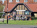
 Jack's Cafe Park Lane Covid-19 pandemic in Tottenham London England 1.jpg 4,439 × 3,329; 11.19 MB
-
 Jack's Cafe Park Lane Covid-19 pandemic in Tottenham London England 2.jpg 4,554 × 3,415; 11.6 MB
-
 Jack's Cafe Park Lane Covid-19 pandemic in Tottenham London England 3.jpg 4,252 × 3,402; 10.96 MB
-
 Totenham Hotspur Stadium during Covid-19 pandemic Haringey London England 5.jpg 3,385 × 4,513; 14.04 MB
-
 Totenham Hotspur Stadium during Covid-19 pandemic Haringey London England 6.jpg 3,110 × 4,665; 13.17 MB
-
 Totenham Hotspur Stadiun during Covid-19 pandemic Haringey London England 7.jpg 2,942 × 3,923; 8.64 MB
-

-

-
 Public telephone during Covid-19 pandemic, High Road, Tottenham London England 1.jpg 2,946 × 4,419; 7.97 MB
-

-
 Public telephone during Covid-19 pandemic, High Road, Tottenham London England 2.jpg 3,271 × 4,361; 8.32 MB
-
 Public telephone during Covid-19 pandemic, High Road, Tottenham London England 3.jpg 3,379 × 4,506; 9.24 MB
-
 Rubbish and fly-tipping Tottenham High Road Haringey London England 2.jpg 3,200 × 4,000; 9.6 MB
-
 Rubbish and fly-tipping Tottenham High Road Haringey London England 1.jpg 3,160 × 4,213; 10 MB
-
 Fibre broadband Fibre Distribution Hub outdoor enclosure Tottenham, London 01.jpg 3,325 × 2,078; 6.42 MB
-
 Fibre broadband Fibre Distribution Hub outdoor enclosure Tottenham, London 02.jpg 2,182 × 2,728; 5.34 MB
-
 Dry Grass in Tottenham, London, England 1.jpg 3,834 × 2,157; 18.04 MB
-
 Broadwater Farm Estate rubbish dumping Tottenham 04.jpg 3,748 × 2,108; 8.98 MB
-
 Broadwater Farm Estate rubbish dumping Tottenham 05.jpg 4,032 × 2,268; 10.08 MB
-
 Flying vermin with bread detritus Tottenham, London, England 1.jpg 3,826 × 2,152; 13.54 MB
-
 Dumped rubbish Haringey Council property London England 1.jpg 3,124 × 2,083; 7.37 MB
-
 Dumped rubbish Haringey Council property London England 2.jpg 3,655 × 2,056; 6.74 MB
-
 Dumped rubbish Haringey Council property London England 3.jpg 3,642 × 2,048; 7.36 MB
-
 Tottenham Hotspur Stadium Dec 2023 01 darker.jpg 4,613 × 2,595; 11.29 MB
-
 Tottenham Hotspur Stadium Dec 2023 01 lighter.jpg 4,613 × 2,595; 11.43 MB
-
 Tottenham Hotspur Stadium Dec 2023 02 darker.jpg 4,610 × 2,593; 12.43 MB
-
 Tottenham Hotspur Stadium Dec 2023 02 lighter.jpg 4,610 × 2,593; 12.58 MB
-
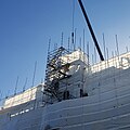
 Scaffold covering in Tottenham London 01 from camera.jpg 4,032 × 2,268; 5.38 MB
-
 Scaffold covering in Tottenham London 01 processed.jpg 4,032 × 2,268; 8.84 MB
-
 Scaffold covering in Tottenham London 02 from camera.jpg 4,032 × 2,268; 5.17 MB
-
 Scaffold covering in Tottenham London 02 processed.jpg 4,032 × 2,268; 8.72 MB
-
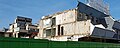
 Building demolition in Tottenham London 01a.jpg 3,046 × 1,039; 3.01 MB
-
 Building demolition in Tottenham London 01b.jpg 2,990 × 1,293; 3.8 MB
-
 Building demolition in Tottenham London 02a.jpg 3,937 × 1,125; 4.2 MB
-
 Building demolition in Tottenham London 02b.jpg 3,773 × 1,519; 5.68 MB
-
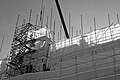
 Scaffold covering in Tottenham London 03 B+W.jpg 2,056 × 2,056; 2.39 MB
-
 Scaffold covering in Tottenham London 03 from camera.jpg 2,063 × 2,063; 3.01 MB
-
 Scaffold covering in Tottenham London 03 processed.jpg 2,056 × 2,056; 3.52 MB
-
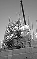
 Scaffold covering in Tottenham London 04 B+W.jpg 3,074 × 2,049; 3.17 MB
-
 Scaffold covering in Tottenham London 04 from camera.jpg 3,074 × 2,049; 4.14 MB
-
 Scaffold covering in Tottenham London 04 processed.jpg 3,074 × 2,049; 4.86 MB
-
 Scaffold covering in Tottenham London 05 B+W.jpg 2,268 × 3,629; 4.03 MB
-
 Scaffold covering in Tottenham London 05 from camera.jpg 2,268 × 3,629; 4.7 MB
-
 Scaffold covering in Tottenham London 05 processed.jpg 2,268 × 3,629; 5.93 MB
-
 Scaffold covering in Tottenham London 06 B+W.jpg 1,909 × 3,394; 3.24 MB
-
 Scaffold covering in Tottenham London 06 from camera.jpg 1,909 × 3,394; 4.3 MB
-
 Scaffold covering in Tottenham London 06 processed.jpg 1,909 × 3,394; 4.95 MB
-
 Building demolition in Tottenham London 03 B+W.jpg 3,573 × 1,579; 3.81 MB
-
 Building demolition in Tottenham London 03 from camera.jpg 3,573 × 1,579; 4.63 MB
-
 Building demolition in Tottenham London 03 processed.jpg 3,573 × 1,579; 5.53 MB
-
 Broadwater Farm Estate rubbish dumping Tottenham 06.jpg 4,032 × 2,268; 13.6 MB
-
 Broadwater Farm Estate rubbish dumping Tottenham 07.jpg 2,386 × 1,908; 5.17 MB
-
 Disabled toilet hand basin, Kwik-Fit, Tottenham, London, England.jpg 2,145 × 3,813; 7.3 MB
-
 Disabled toilet, Kwik-Fit, Tottenham, London, England.jpg 2,268 × 3,402; 6.76 MB
-
 259-331 Lordship Lane, London N17 - geograph.org.uk - 1407761.jpg 640 × 480; 60 KB
-
 341-385 Lordship Lane, London N17 - geograph.org.uk - 1407802.jpg 640 × 317; 57 KB
-
 342 to 384 Lordship Lane London N17.jpg 1,627 × 934; 263 KB
-
 347-351 Lordship Lane, London N17 - geograph.org.uk - 1407798.jpg 626 × 640; 132 KB
-
 530-536 High Road - Demolition (6171909104).jpg 480 × 288; 51 KB
-
 After the Riot - William Hill.jpeg 3,378 × 2,300; 1.16 MB
-
 Atlas Equipment Company Lordship Lane N17.jpg 2,046 × 1,461; 597 KB
-
 Back of Bruce Castle.JPG 4,608 × 3,456; 4.14 MB
-

-
 Bruce Castle Park - geograph.org.uk - 293923.jpg 640 × 421; 101 KB
-
 Bruce Castle Park.JPG 3,264 × 2,448; 3.71 MB
-
 Cinematograph Cinema Lordship Lane N17 1913.jpg 1,824 × 946; 805 KB
-
 Cycle path on The Roundway Tottenham London England.jpg 4,608 × 3,456; 9.39 MB
-
 Elmhurst Hotel Lordship Lane N17.jpg 1,998 × 1,364; 419 KB
-

-
 Fly-tipping at the Selby Centre.jpg 3,570 × 2,600; 1.95 MB
-
 Former Gas Showrooms at E end of Lordship Lane N17.jpg 1,947 × 1,140; 329 KB
-
 Hale Village, N17, 230 Bus. (4586789307).jpg 2,133 × 1,600; 694 KB
-
 High Road Tottenham - Betting Shops.jpeg 3,880 × 3,400; 2.24 MB
-
 High Road Tottenham Betting Shops.jpeg 3,230 × 2,736; 1.55 MB
-
 High Road Tottenham, London N17 - geograph.org.uk - 354897.jpg 640 × 510; 96 KB
-
 High Road Tottenham, London N17 - geograph.org.uk - 354902.jpg 640 × 462; 98 KB
-
 High Road, Tottenham, Haringey, London N17.jpg 2,812 × 2,101; 928 KB
-
 Hill & Bell & Hare (6965443675).jpg 3,600 × 1,800; 1.43 MB
-
 Holcombe Road N17 - geograph.org.uk - 189477.jpg 640 × 480; 96 KB
-
 Kolok CarbonPaper.jpg 768 × 982; 432 KB
-
 Ladbrokes - 263 Park Lane (2299743817).jpg 3,200 × 2,400; 1.43 MB
-
 Ladbrokes - corner of Lordship Lane & The Roundway (5995110711) (2).jpg 1,920 × 2,560; 899 KB
-
-
 Local supermarket on The Roundway Tottenham London England.jpg 4,608 × 3,456; 7.95 MB
-
 Lordship Lane N17 (1) - geograph.org.uk - 189397.jpg 640 × 480; 119 KB
-
 Lordship Lane N17 (2) - geograph.org.uk - 189408.jpg 640 × 480; 117 KB
-
 Millicent Fawcett Court (North Block) from Lordship Lane N17.jpg 1,992 × 1,094; 352 KB
-
 Morrison Yard.jpeg 3,333 × 2,409; 1.19 MB
-
 Nicolas House Lordship Lane N17.jpg 2,028 × 1,188; 350 KB
-
 Number 26 Lordship Lane N17 - Gosport Engineering Co Ltd.jpg 2,048 × 1,218; 641 KB
-
 Numbers 132 to 138 Lordship Lane N17.jpg 2,048 × 1,334; 620 KB
-
 Numbers 2 to 6 Lordship Lane N17.jpg 1,578 × 1,215; 381 KB
-
 Numbers 2 to 6 Lordship Lane N17.png 1,578 × 1,215; 3.66 MB
-
 Numbers 259 to 331 Lordship Lane N17.jpg 2,048 × 1,536; 350 KB
-
 Numbers 28 to 34 Lordship Lane N17.jpg 1,998 × 1,290; 582 KB
-
 Numbers 341 to 385 Lordship Lane N17.jpg 1,748 × 751; 442 KB
-
 Numbers 347 to 351 Lordship Lane N17.jpg 1,014 × 1,036; 210 KB
-
 Numbers 387 to 403b Lordship Lane N17.jpg 1,768 × 808; 236 KB
-
 Numbers 409 to 419 Lordship Lane N17.jpg 1,638 × 938; 276 KB
-
 Numbers 52 to 56 Lordship Lane N17.jpg 2,034 × 938; 457 KB
-
 Numbers 8 to 18 Lordship Lane N17.jpg 2,050 × 1,228; 703 KB
-
 Opera House Finished (49319321552).jpg 4,000 × 2,667; 1.74 MB
-
 OS Edition1 1864 25inch map of Lordship Lane N17 and N22.png 3,631 × 679; 1.3 MB
-
 OS Edition2 1895 25inch map of Lordship Lane N17 and N22.png 2,904 × 608; 1.16 MB
-
 Outside Bruce Grove Post Office - August 2012 (7810857552).jpg 2,435 × 1,827; 758 KB
-
 Paddy Power & William Hill - Lordship Lane betting shops (5994966745) (2).jpg 6,200 × 2,950; 2.91 MB
-
 Parish Church of All Hallows.JPG 2,592 × 1,936; 1.2 MB
-
 Park Lane, London N17 - geograph.org.uk - 354874.jpg 640 × 479; 113 KB
-
 Park Lane, London N17 - geograph.org.uk - 354879.jpg 640 × 479; 99 KB
-
 Public toilets outside recreation ground Lordship Lane N17.jpg 1,794 × 1,166; 467 KB
-
 Scales Road, London N17 -mattress mountain-9Aug2006.jpg 1,400 × 1,050; 341 KB
-
 Tall Storeys at Tottenham Hale? (4080787755) (2).jpg 3,380 × 2,535; 1.55 MB
-
 Tottenham, Walpole Road, N17 - geograph.org.uk - 235545.jpg 640 × 480; 99 KB
-
 White Hart, Tottenham, N17 (6880800922).jpg 3,461 × 2,342; 3.76 MB
-
 William Hill at the corner of White Hart Lane (2233097845).jpg 3,300 × 2,476; 1.89 MB


.jpg)


.jpg)


.jpg)


.jpg)
_(2).jpg)


_-_geograph.org.uk_-_189397.jpg)
_-_geograph.org.uk_-_189408.jpg)
_from_Lordship_Lane_N17.jpg)


.jpg)
.jpg)
_(2).jpg)


_(2).jpg)

.jpg)
.jpg)