Category:Lynton and Lynmouth
civil parish in North Devon, Devon, England  | |||||
| Upload media | |||||
| Instance of | |||||
|---|---|---|---|---|---|
| Named after | |||||
| Location | North Devon, Devon, South West England, England | ||||
| Population |
| ||||
 | |||||
Subcategories
This category has the following 14 subcategories, out of 14 total.
B
- Barbrook (9 F)
G
- Glen Lyn Gorge (13 F)
H
L
M
R
- Roborough Castle (2 F)
S
V
W
- Watersmeet, Devon (43 F)
- Wind Hill, Devon (2 F)
Media in category "Lynton and Lynmouth"
The following 200 files are in this category, out of 1,423 total.
(previous page) (next page)-
 'Modern and Ancient' - geograph.org.uk - 6216156.jpg 1,024 × 768; 481 KB
-
 'Rock House' Lynmouth - geograph.org.uk - 6101473.jpg 1,024 × 748; 206 KB
-
 26 - 27 Tors Road - geograph.org.uk - 6360507.jpg 1,024 × 678; 801 KB
-
 26 - 27 Tors Road - geograph.org.uk - 6360509.jpg 678 × 1,024; 868 KB
-
 3 - 4 Croscombe Lane - geograph.org.uk - 6351765.jpg 1,024 × 678; 610 KB
-
 A blocked off view in Six Acre Wood - geograph.org.uk - 5460221.jpg 6,000 × 4,000; 6.74 MB
-

-
 A field of cut grass by Caffyns Cross - geograph.org.uk - 5461239.jpg 6,000 × 4,000; 5.35 MB
-
 A picture postcard view - geograph.org.uk - 6215373.jpg 1,024 × 768; 595 KB
-
 A wet day for planting - geograph.org.uk - 2807148.jpg 708 × 480; 182 KB
-
 A wild strawberry - geograph.org.uk - 3534982.jpg 1,238 × 1,500; 129 KB
-
 A39 - geograph.org.uk - 5915770.jpg 6,000 × 4,000; 1.54 MB
-
 A39 at Hilsford Bridge.jpg 3,991 × 2,684; 5.11 MB
-
 A39 between East Lyn River and Oxen Tor - geograph.org.uk - 5689431.jpg 1,600 × 1,200; 831 KB
-
 A39 descends to Lynmouth - geograph.org.uk - 477243.jpg 640 × 443; 252 KB
-
 A39 in Dean Plantation - geograph.org.uk - 5688061.jpg 1,600 × 1,331; 735 KB
-
 A39 near Dean - geograph.org.uk - 4247683.jpg 1,280 × 720; 1.54 MB
-
 A39 on Countisbury Hill and view to Lynton - geograph.org.uk - 6034583.jpg 1,600 × 1,596; 748 KB
-
 A39 passing entrance to Middle Ranscombe Farm - geograph.org.uk - 6399498.jpg 1,600 × 889; 416 KB
-
 A39 Watersmeet Road - geograph.org.uk - 3760426.jpg 800 × 600; 383 KB
-
 A39, Countisbury Hill - geograph.org.uk - 6034578.jpg 1,600 × 1,197; 573 KB
-

-
 Above Dean - geograph.org.uk - 2000825.jpg 640 × 427; 255 KB
-
 Above Duty Point - geograph.org.uk - 5994527.jpg 1,024 × 678; 854 KB
-
 Above Duty Point - geograph.org.uk - 5994532.jpg 1,024 × 678; 1,009 KB
-
 Above Duty Point - geograph.org.uk - 5994534.jpg 1,024 × 678; 879 KB
-
 Above Myrtleberry Cleave - geograph.org.uk - 1307116.jpg 640 × 480; 96 KB
-
 Access to A39 - geograph.org.uk - 3182963.jpg 640 × 427; 206 KB
-
 Access to Myrtleberry and Watersmeet - geograph.org.uk - 5689441.jpg 1,600 × 1,203; 794 KB
-
 Across Lynmouth Bay - geograph.org.uk - 2000426.jpg 640 × 427; 221 KB
-
 Aladdin's Cave, Lynmouth - geograph.org.uk - 4752096.jpg 1,200 × 799; 353 KB
-
 Along to Butter Hill - geograph.org.uk - 5123086.jpg 3,648 × 2,432; 4.69 MB
-
 Approach to Lynmouth - geograph.org.uk - 3182991.jpg 640 × 427; 186 KB
-
 At Anchor on the Lyn - geograph.org.uk - 4552175.jpg 1,580 × 2,334; 784 KB
-
 Atlantic Salmon - geograph.org.uk - 202879.jpg 640 × 346; 49 KB
-
 Balancing goat, Valley of Rocks - geograph.org.uk - 4148089.jpg 1,333 × 1,000; 977 KB
-
 Barbrook - geograph.org.uk - 5240614.jpg 6,000 × 4,000; 6.48 MB
-
 Barbrook -The West Lyn River - geograph.org.uk - 4074854.jpg 1,024 × 768; 324 KB
-
 Barbrook Bridge - geograph.org.uk - 498681.jpg 640 × 426; 148 KB
-
 Barbrook Road - geograph.org.uk - 3782655.jpg 1,024 × 768; 286 KB
-
 Barbrook Road - geograph.org.uk - 6361343.jpg 1,024 × 678; 979 KB
-
 Barbrook Valley - geograph.org.uk - 1003204.jpg 640 × 427; 79 KB
-
 Barn at Lyn Cross on A39 - geograph.org.uk - 6399487.jpg 1,200 × 1,600; 1.06 MB
-
 Beech hedge on Furzehill Common - geograph.org.uk - 4374175.jpg 1,024 × 768; 180 KB
-
 Beggars Roost Inn and Exmoor Manor Hotel - geograph.org.uk - 6360897.jpg 1,024 × 678; 819 KB
-
 Beggars Roost Inn and Exmoor Manor Hotel - geograph.org.uk - 6360898.jpg 1,024 × 678; 836 KB
-
 Below Castle Rock - geograph.org.uk - 6002950.jpg 1,024 × 678; 706 KB
-
 Below Six Acre Farm - geograph.org.uk - 6351760.jpg 1,024 × 678; 1.11 MB
-
 Below Six Acre Farm - geograph.org.uk - 6351761.jpg 1,024 × 678; 1.05 MB
-
 Below Six Acre Farm - geograph.org.uk - 6351762.jpg 1,024 × 678; 1.07 MB
-
 Benjamy - geograph.org.uk - 650524.jpg 640 × 426; 56 KB
-
 Berry Lawn Linhay - geograph.org.uk - 1307142.jpg 640 × 480; 66 KB
-
 Black signpost, Riverside Road, Lynmouth - geograph.org.uk - 5251271.jpg 749 × 800; 222 KB
-

-
 Blacklands Wood and Countisbury Hill - geograph.org.uk - 5717598.jpg 3,599 × 2,399; 1.07 MB
-
 Blocked path to Watersmeet, Lynmouth, Devon - geograph.org.uk - 3009223.jpg 1,600 × 1,200; 843 KB
-
 Bluebells in Caffyns Heanton Wood - geograph.org.uk - 3984746.jpg 1,024 × 774; 269 KB
-
 Boat trip from Lynmouth - geograph.org.uk - 5670325.jpg 6,496 × 4,288; 2.29 MB
-
 Boats in Lynmouth harbour - geograph.org.uk - 5911680.jpg 1,024 × 683; 268 KB
-
 Boggy bit on Ilkerton Ridge - geograph.org.uk - 5457421.jpg 6,000 × 4,000; 6.71 MB
-
 Bonhill Bridge - geograph.org.uk - 6351883.jpg 678 × 1,024; 1.01 MB
-
 Bonhill Cottage - geograph.org.uk - 6351878.jpg 1,024 × 678; 1.01 MB
-
 Bonhill Cottage - geograph.org.uk - 6351881.jpg 1,024 × 678; 905 KB
-
 Bonnicott House name sign, Lynmouth - geograph.org.uk - 4783350.jpg 800 × 600; 216 KB
-
 Boundaries on Furzehill Common - geograph.org.uk - 4374273.jpg 1,024 × 768; 225 KB
-
 Breaking waves at the harbour entrance, Lynmouth - geograph.org.uk - 3782706.jpg 1,024 × 768; 150 KB
-
 Bridge abutment - geograph.org.uk - 6351533.jpg 1,024 × 678; 869 KB
-
 Bridge at Shallow Ford - geograph.org.uk - 4305254.jpg 1,024 × 768; 194 KB
-
 Bridge near Shallowford - geograph.org.uk - 1004174.jpg 640 × 427; 80 KB
-
 Bridge over Barbrook on Exmoor - geograph.org.uk - 414132.jpg 640 × 480; 98 KB
-
 Bridge over Hoar Oak Water, Watersmeet - geograph.org.uk - 4148133.jpg 1,333 × 1,000; 1.47 MB
-
 Bridge over the River Lyn - geograph.org.uk - 5114630.jpg 1,024 × 817; 255 KB
-
 Bridge over the West Lyn River - geograph.org.uk - 4305897.jpg 1,024 × 768; 226 KB
-
 Bridleway down to Hoaroak Water - geograph.org.uk - 3659295.jpg 640 × 480; 128 KB
-
 Bridleway to Furzehill - geograph.org.uk - 5457389.jpg 6,000 × 4,000; 5.86 MB
-
 Bridleway to Saddle Gate - geograph.org.uk - 1003142.jpg 640 × 427; 84 KB
-
 Bridleway to Thornworthy - geograph.org.uk - 5240589.jpg 6,000 × 4,000; 5.05 MB
-
 Bridleway to Wind Hill, near Countisbury - geograph.org.uk - 3007720.jpg 1,600 × 1,200; 500 KB
-
 Bridleway towards West Ilkerton - geograph.org.uk - 5240601.jpg 6,000 × 4,000; 6.02 MB
-
 Bristol channel covered in fog, Near Lynton and Lynmouth (2545085053).jpg 2,518 × 2,750; 1.53 MB
-
 Bristol channel covered in fog, Near Lynton and Lynmouth (2545911334).jpg 2,412 × 2,503; 1.23 MB
-
 Buildings on the slope of Watersmeet Road, Lynmouth - geograph.org.uk - 5688811.jpg 1,600 × 1,200; 747 KB
-
 Buildings overlooking Lynmouth harbour - geograph.org.uk - 5911682.jpg 1,024 × 683; 190 KB
-
 Bust of Sir George Newnes, Lynton Town Hall - geograph.org.uk - 6296387.jpg 892 × 1,024; 311 KB
-
 Butler Hill towards Lynton - geograph.org.uk - 5163097.jpg 5,184 × 3,456; 3.12 MB
-
 Butter Hill - geograph.org.uk - 1002966.jpg 640 × 427; 69 KB
-
 Butter Hill - geograph.org.uk - 1002995.jpg 640 × 427; 83 KB
-
 Caffyns Cross - geograph.org.uk - 2698497.jpg 1,024 × 768; 136 KB
-
 Caffyns Farm - geograph.org.uk - 6351775.jpg 1,024 × 678; 612 KB
-
 Caffyns Halt - geograph.org.uk - 4950761.jpg 1,600 × 1,200; 623 KB
-
 Caffyns Heanton Combe - geograph.org.uk - 2001085.jpg 640 × 427; 250 KB
-
 Caffyns Heanton Down, aerial 2018 - geograph.org.uk - 5954758.jpg 800 × 533; 71 KB
-
 Caffyns Heanton Wood - geograph.org.uk - 2001089.jpg 640 × 427; 230 KB
-
 Caffyns Heanton Wood - geograph.org.uk - 6352018.jpg 1,024 × 678; 1.11 MB
-
 Captains House, Lynmouth - geograph.org.uk - 4750521.jpg 1,200 × 799; 563 KB
-
 Car park and rock formations, Valley of the Rocks - geograph.org.uk - 5688381.jpg 1,600 × 1,199; 576 KB
-
 Car park at Lee Bay - geograph.org.uk - 2000711.jpg 640 × 427; 190 KB
-
 Car park off Castle Hill, Lynton - geograph.org.uk - 4736149.jpg 1,200 × 799; 289 KB
-
 Car Park on the Esplanade, Lynmouth - geograph.org.uk - 4752122.jpg 1,200 × 799; 327 KB
-
 Car Park on the Esplanade, Lynmouth - geograph.org.uk - 4752137.jpg 1,200 × 799; 343 KB
-
 Caravan Site on Lynbridge Road, Lynbridge - geograph.org.uk - 4756500.jpg 1,200 × 816; 419 KB
-
 Castle Field Trig, Lynton - geograph.org.uk - 3275673.jpg 2,560 × 1,920; 3.19 MB
-
 Castle Hill from Station Hill, Lynton - geograph.org.uk - 6296645.jpg 1,024 × 683; 165 KB
-
 Castle Hill, Lynton - geograph.org.uk - 5551130.jpg 800 × 533; 81 KB
-
 Castle Hill, Lynton - geograph.org.uk - 5688361.jpg 1,600 × 1,201; 824 KB
-
 Castle Rock - geograph.org.uk - 2000677.jpg 640 × 426; 235 KB
-
 Castle Rock - geograph.org.uk - 2000681.jpg 426 × 640; 216 KB
-
 Castle Rock - geograph.org.uk - 2698194.jpg 1,024 × 768; 149 KB
-
 Castle Rock - geograph.org.uk - 2825033.jpg 640 × 416; 50 KB
-
 Castle Rock - geograph.org.uk - 5219924.jpg 1,000 × 662; 825 KB
-
 Castle Rock - geograph.org.uk - 5219925.jpg 1,000 × 662; 922 KB
-
 Castle Rock - geograph.org.uk - 5823424.jpg 1,024 × 678; 769 KB
-
 Castle Rock - geograph.org.uk - 5823426.jpg 1,024 × 678; 1,015 KB
-
 Castle Rock - geograph.org.uk - 5823427.jpg 678 × 1,024; 983 KB
-
 Castle Rock - geograph.org.uk - 5823549.jpg 1,024 × 678; 711 KB
-
 Castle Rock - geograph.org.uk - 5823554.jpg 1,024 × 678; 706 KB
-
 Castle Rock - geograph.org.uk - 5994559.jpg 1,024 × 678; 883 KB
-
 Castle Rock - geograph.org.uk - 5994585.jpg 678 × 1,024; 968 KB
-
 Castle Rock - geograph.org.uk - 6009468.jpg 1,024 × 678; 666 KB
-
 Castle Rock - geograph.org.uk - 6012216.jpg 678 × 1,024; 994 KB
-
 Castle Rock and autumn bracken - geograph.org.uk - 3733991.jpg 3,264 × 2,448; 2.59 MB
-
 Castle Rock and Rugged Jack - geograph.org.uk - 2133503.jpg 1,024 × 682; 223 KB
-
 Castle Rock and Rugged Jack - geograph.org.uk - 5823418.jpg 1,024 × 729; 784 KB
-
 Castle Rock and Rugged Jack - geograph.org.uk - 5994600.jpg 1,024 × 678; 868 KB
-
 Castle Rock and the Valley of Rocks - geograph.org.uk - 5994576.jpg 1,024 × 678; 708 KB
-
 Castle Rock and the Valley of Rocks - geograph.org.uk - 5994590.jpg 1,024 × 678; 730 KB
-
 Castle Rock and Wringcliff Bay - geograph.org.uk - 5994596.jpg 678 × 1,024; 809 KB
-
 Castle Rock at dawn - geograph.org.uk - 5819495.jpg 1,024 × 678; 636 KB
-
 Castle Rock at Wringcliff Bay - geograph.org.uk - 5111216.jpg 1,024 × 771; 98 KB
-
 Castle Rock Cottage - geograph.org.uk - 6009488.jpg 1,024 × 678; 844 KB
-
 Castle Rock from the South-West Coast Path - geograph.org.uk - 3531847.jpg 1,500 × 992; 301 KB
-
 Castle Rock in the Valley of Rocks - geograph.org.uk - 3733978.jpg 3,264 × 2,448; 3.31 MB
-
 Castle Rock, Lynton - geograph.org.uk - 3275658.jpg 2,560 × 1,920; 3.25 MB
-
 Castle Rock, Lynton - geograph.org.uk - 3733996.jpg 3,264 × 2,448; 3.2 MB
-
 Castle Rock, the Valley of Rocks, Lynton - geograph.org.uk - 5917596.jpg 4,000 × 3,000; 4.76 MB
-

-
 Cattle at Lee Abbey - geograph.org.uk - 5459024.jpg 5,700 × 3,800; 6.31 MB
-
 Cattle grid at the edge of the Valley of the Rocks - geograph.org.uk - 5688369.jpg 1,600 × 1,200; 569 KB
-
 Cattle grid near East Ilkerton - geograph.org.uk - 4304440.jpg 1,024 × 798; 213 KB
-
 Cattle grid on the west edge of the Valley of the Rocks - geograph.org.uk - 5688401.jpg 1,600 × 1,160; 809 KB
-
 Cattle near Dean - geograph.org.uk - 5461199.jpg 6,000 × 4,000; 6.23 MB
-
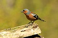 Chaffinch (190069617).jpeg 2,048 × 1,364; 423 KB
-
 Chalets at Lee Bay - geograph.org.uk - 739498.jpg 640 × 498; 95 KB
-
 Cheriton Ford - geograph.org.uk - 5926050.jpg 4,032 × 3,024; 3.87 MB
-
 Chiselcombe Bridge - geograph.org.uk - 3533897.jpg 1,024 × 768; 345 KB
-
 Chiselcombe Bridge - geograph.org.uk - 4410638.jpg 1,600 × 1,200; 796 KB
-
 Chiselcombe Bridge - geograph.org.uk - 6134102.jpg 2,340 × 1,560; 3.45 MB
-
 Chiselcombe Bridge and the East Lyn River - geograph.org.uk - 5659179.jpg 6,512 × 4,272; 3.04 MB
-
 Church and convent of Holy Saviour's, Lynton - geograph.org.uk - 6101481.jpg 1,024 × 768; 131 KB
-
 Church of St Mary the Virgin, Lynton - geograph.org.uk - 5993199.jpg 678 × 1,024; 682 KB
-
 Church of St Mary the Virgin, Lynton - geograph.org.uk - 5993201.jpg 1,024 × 678; 640 KB
-
 Church of St Mary the Virgin, Lynton - geograph.org.uk - 6003590.jpg 678 × 1,024; 692 KB
-
 Cliff path, above Ruddy Ball - geograph.org.uk - 2698067.jpg 1,024 × 768; 146 KB
-
 Cliff path, to the west of Lynton - geograph.org.uk - 2972841.jpg 1,024 × 768; 244 KB
-
 Cliff-side path - geograph.org.uk - 6003181.jpg 1,024 × 678; 696 KB
-
 Cliff-side path - geograph.org.uk - 6004123.jpg 1,024 × 678; 851 KB
-
 Cliffe House, Lynmouth - geograph.org.uk - 3534894.jpg 1,024 × 781; 296 KB
-
 Cliffs - geograph.org.uk - 6004121.jpg 678 × 1,024; 943 KB
-
 Cliffs - geograph.org.uk - 6004366.jpg 678 × 1,024; 737 KB
-
 Cliffs looking West - geograph.org.uk - 2894094.jpg 2,949 × 2,245; 830 KB
-
 Clifftops near Lynmouth - geograph.org.uk - 2027171.jpg 1,139 × 668; 444 KB
-
 Clooneavin Hotel, Lynmouth - geograph.org.uk - 4748023.jpg 1,200 × 799; 577 KB
-
 Closed footbridge on the River Lyn - geograph.org.uk - 5112706.jpg 1,024 × 768; 295 KB
-
 Clouds and Lynmouth seafront - geograph.org.uk - 5051100.jpg 4,896 × 3,672; 6.02 MB
-

-
 Coarse grasses on Furzehill Common - geograph.org.uk - 4374222.jpg 1,024 × 768; 197 KB
-
 Coast Path - geograph.org.uk - 4467111.jpg 1,600 × 1,200; 606 KB
-
 Coast path east of Lynmouth - geograph.org.uk - 1306760.jpg 640 × 480; 100 KB
-
 Coast path east of Lynmouth - geograph.org.uk - 890829.jpg 640 × 512; 60 KB
-
 Coast path on Hollerday Hill - geograph.org.uk - 560562.jpg 640 × 480; 137 KB
-
 Coast path round Hollerday Hill - geograph.org.uk - 5458995.jpg 6,000 × 4,000; 5.33 MB
-
 Coast path to Foreland Point - geograph.org.uk - 1306881.jpg 640 × 480; 83 KB
-
 Coastal Cliffs - geograph.org.uk - 5354455.jpg 1,333 × 2,000; 2.61 MB
-
 Coastal path - off Esplanade - geograph.org.uk - 5395170.jpg 640 × 480; 112 KB
-
-
 Coastal path, west of Lynton - geograph.org.uk - 2698110.jpg 1,024 × 768; 196 KB
-
 Coastal slopes near Countisbury - geograph.org.uk - 1306905.jpg 640 × 447; 88 KB
-
 Combe below Barham Hill - geograph.org.uk - 5240594.jpg 6,000 × 4,000; 4.67 MB
-
 Combe Park House - geograph.org.uk - 3659258.jpg 640 × 480; 117 KB
-
 Companions on the path, North Walk, Lynton - geograph.org.uk - 3004524.jpg 1,600 × 1,200; 306 KB
-
 Confluence of Barbrook and the West Lyn River - geograph.org.uk - 5457430.jpg 5,189 × 3,459; 7.01 MB
-
 Copse - geograph.org.uk - 5994921.jpg 1,024 × 678; 1.05 MB
-
 Cottage near Lee Abbey - geograph.org.uk - 1471552.jpg 640 × 480; 101 KB
-
 Cottages at Furzhill - geograph.org.uk - 4305426.jpg 1,024 × 768; 250 KB
-
 Cottages at Lynbridge - geograph.org.uk - 5452583.jpg 5,700 × 3,800; 6.17 MB
-
 Cottages in Barbrook - geograph.org.uk - 5457433.jpg 5,700 × 3,800; 5.66 MB
-
 Cotton grass on Ilkerton Ridge - geograph.org.uk - 5034330.jpg 1,024 × 768; 407 KB
-
 Countisbury , The A39 - geograph.org.uk - 5057141.jpg 5,451 × 3,633; 5.64 MB
-
 Countisbury Hill - geograph.org.uk - 5394524.jpg 640 × 461; 90 KB
-
 Countisbury Hill - geograph.org.uk - 6216095.jpg 1,024 × 768; 334 KB
-
 Countisbury Hill from The Lynton railway - geograph.org.uk - 3823311.jpg 1,600 × 1,200; 253 KB
-
 Countisbury Hill leading down to Lynmouth - geograph.org.uk - 6442076.jpg 1,800 × 1,200; 313 KB
-
 Countisbury Hill, Lynmouth - geograph.org.uk - 5251202.jpg 800 × 587; 195 KB
-
 Course of East Lyn River - geograph.org.uk - 3182943.jpg 640 × 427; 173 KB
-
 Cows having a drink near West Lyn - geograph.org.uk - 5452634.jpg 5,762 × 3,842; 5.06 MB
-
 Crest of the hill on the A39 - Lynton in the background - geograph.org.uk - 3007726.jpg 1,600 × 1,200; 479 KB
-
 Cricket ground in The valley of Rocks - geograph.org.uk - 3735817.jpg 3,264 × 2,448; 4.15 MB
-
 Crock Point - geograph.org.uk - 5997723.jpg 1,024 × 678; 564 KB
-
 Croscombe Barton - geograph.org.uk - 2000758.jpg 640 × 428; 255 KB
-
 Croscombe Barton - geograph.org.uk - 5472227.jpg 6,000 × 4,000; 4.53 MB


.jpg)
.jpg)


.jpeg)


