Category:Maps about the COVID-19 pandemic in Italy
Countries of Europe: Albania · Armenia‡ · Austria · Azerbaijan‡ · Belarus · Belgium · Bosnia and Herzegovina · Bulgaria · Croatia · Czech Republic · Denmark · Estonia · Finland · France‡ · Georgia‡ · Germany · Greece · Hungary · Iceland · Republic of Ireland · Italy · Kazakhstan‡ · Latvia · Liechtenstein · Lithuania · Luxembourg · Malta · Moldova · Monaco · Montenegro · Netherlands‡ · North Macedonia · Norway · Poland · Portugal‡ · Romania · Russia‡ · San Marino · Serbia · Slovakia · Slovenia · Spain‡ · Sweden · Switzerland · Turkey‡ · Ukraine · United Kingdom
Limited recognition: Abkhazia‡ · Kosovo
‡: partly located in Europe
Limited recognition: Abkhazia‡ · Kosovo
‡: partly located in Europe
Subcategories
This category has only the following subcategory.
Media in category "Maps about the COVID-19 pandemic in Italy"
The following 17 files are in this category, out of 17 total.
-
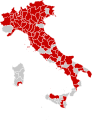
 Colori delle province italiane (6 marzo 2021).png 5,300 × 6,785; 2.99 MB
-
 Coronavirus outbreak associated travel restrictions regarding Italy.svg 2,754 × 1,398; 1.06 MB
-

-
 COVID-19 Italy - Cases per capita (last 14 days).svg 512 × 653; 128 KB
-
 COVID-19 Italy - Cases per capita.svg 512 × 653; 126 KB
-
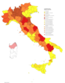
 COVID-19 Outbreak Cases in Italy (Density).svg 1,440 × 1,877; 298 KB
-
 COVID-19 Outbreak Cases in Italy.svg 1,000 × 1,301; 177 KB
-
 COVID-19 outbreak Italy per capita cases map.svg 1,440 × 1,877; 288 KB
-
 Deaths in Italy from covid19.png 981 × 1,129; 179 KB
-
 ICU patients in Italy from covid19.png 981 × 1,129; 183 KB
-
 Italian COVID19 contagious.png 1,421 × 622; 43 KB
-
 Patients recovered from covid19 in Italy.jpg 981 × 1,129; 143 KB
-
 Patients recovered from covid19 in Italy.png 981 × 1,129; 190 KB
-
 People Vaccinated per Region.png 685 × 459; 35 KB
-
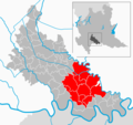 Quarantined areas of LodiProvince.png 1,024 × 961; 294 KB
-
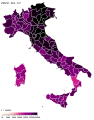
 Regionale Häufigkeit der Infektionen mit SARS-CoV-2 in den Provinzen Italiens.svg 744 × 1,052; 1.34 MB
-
 Restrizioni per gli Italiani COVID19.png 2,754 × 1,398; 502 KB
.png)


.svg)

.svg)


