Category:Maps of Arlington, Massachusetts
Wikimedia category | |||||
| Upload media | |||||
| Instance of | |||||
|---|---|---|---|---|---|
| Category combines topics | |||||
| Arlington | |||||
town in Middlesex County, Massachusetts, United States    | |||||
| Instance of | |||||
| Part of | |||||
| Location | Middlesex County, Massachusetts | ||||
| Inception |
| ||||
| Population |
| ||||
| Area |
| ||||
| Elevation above sea level |
| ||||
| Different from | |||||
| official website | |||||
 | |||||
Subcategories
This category has the following 3 subcategories, out of 3 total.
Media in category "Maps of Arlington, Massachusetts"
The following 29 files are in this category, out of 29 total.
-

-

-

-

-

-

-

-

-

-

-
 Alewife Reservation and Alewife Brook master plan (2003) (17327107974).jpg 3,910 × 2,954; 3.72 MB
-
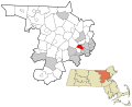
 Arlington ma highlight.png 788 × 466; 55 KB
-
 Arlington's borders, up to 1907.pdf 1,191 × 1,450; 8.99 MB
-
 Arlington, Massachusetts (2675930216).jpg 2,000 × 1,378; 2.52 MB
-
 Arlington, Massachusetts, 1884, from the Digital Commonwealth - commonwealth x633fc56f.jpg 9,712 × 6,688; 76.57 MB
-
 Arlington, Massachusetts, 1884. LOC 2011589045.jpg 12,285 × 8,709; 16.68 MB
-

-

-

-
 Ma towns Arlington.PNG 800 × 490; 40 KB
-

-

-

-
-
 Plan of building lots on the "Kimball" Estate Arlington, Mass. (9475356544).jpg 6,824 × 5,400; 34.74 MB
-
 Plan of lands situated at Arlington Heights, Mass. (3120134621).jpg 2,000 × 1,750; 3.17 MB
-
 The birds of the Cambridge region of Massachusetts (1906) (20804312251).jpg 3,796 × 2,646; 2.03 MB
-
 Topographic maps of Arlington, Belmont, Lexington Massachusetts 1946.jpg 2,560 × 2,440; 2.68 MB
-

_Map_of_Cambridge_roads,_by_Peter_Tufts,_Jr.,_from_the_Digital_Commonwealth_-_commonwealth_wd378h641.jpg)
,_Massachusetts_by_John_Groves_Hales,_from_the_Digital_Commonwealth_-_commonwealth_25152f94h.jpg)


.jpg)
.jpg)
_-_Middlesex_County_-_Arlington_-_ED_9-4_to_70_-_NARA_-_12549101.jpg)
_(17327107974).jpg)
.jpg)


_(page_11_crop).jpg)


,_by_John_G._Hales,_1819_-_reprinted_in_Fresh_Pond,_The_History_of_a_Cambridge_Landscape,_by_Jill_Sinclair,_2009_-_Fresh_Pond,_MA_-_DSC02583.jpg)
,_by_John_G._Hales,_1819_-_reprinted_in_Fresh_Pond,_The_History_of_a_Cambridge_Landscape,_by_Jill_Sinclair,_2009_-_Fresh_Pond,_MA_-_DSC02588.jpg)
_by_John_Hales,_1830_-_reprinted_in_Fresh_Pond,_The_History_of_a_Cambridge_Landscape,_by_Jill_Sinclair,_2009_-_Fresh_Pond,_MA_-_DSC02574.jpg)

.jpg)
.jpg)
_(20804312251).jpg)

,_Massachusetts_-_Henry_Francis_Walling,_1856_-_Library_of_Congress_master-gmd-gmd376-g3763-g3763m-la000316Z.jpg)