Category:Maps of Bellerive-sur-Allier
Wikimedia category | |||||
| Upload media | |||||
| Instance of | |||||
|---|---|---|---|---|---|
| Category combines topics | |||||
| Bellerive-sur-Allier | |||||
commune in Allier, France  Эспланада Франсуа Миттерана .svg) | |||||
| Instance of | |||||
| Named after | |||||
| Location |
| ||||
| Located in or next to body of water | |||||
| Population |
| ||||
| Area |
| ||||
| Elevation above sea level |
| ||||
| official website | |||||
 | |||||
Media in category "Maps of Bellerive-sur-Allier"
The following 7 files are in this category, out of 7 total.
-
 03023-Bellerive-sur-Allier-Hydro.png 3,507 × 2,480; 6.63 MB
-
 03023-Bellerive-sur-Allier-Sols.png 3,270 × 2,598; 4.69 MB
-
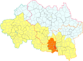
 Map commune FR insee code 03023.png 756 × 605; 82 KB
-
 Vaissa dins la Comunautat d'Aglomeracion Vichèi Val d'Alèir.png 640 × 469; 26 KB
-
 Vaissa dins lo Canton d'Escuròlas.png 640 × 469; 26 KB
-
 Vaissa.png 550 × 450; 229 KB
-
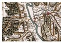 Vesse sur la carte de Cassini.pdf 1,754 × 1,239; 1,023 KB


