Category:Maps of Cascade County, Montana
Counties of Montana: Beaverhead · Big Horn · Blaine · Broadwater · Carbon · Carter · Cascade · Chouteau · Custer · Daniels · Dawson · Deer Lodge · Fallon · Fergus · Flathead · Gallatin · Garfield · Glacier · Golden Valley · Granite · Hill · Jefferson · Judith Basin · Lake · Lewis and Clark · Liberty · Lincoln · Madison · McCone · Meagher · Mineral · Missoula · Musselshell · Park · Petroleum · Phillips · Pondera · Powder River · Powell · Prairie · Ravalli · Richland · Roosevelt · Rosebud · Sanders · Sheridan · Silver Bow · Stillwater · Sweet Grass · Teton · Toole · Treasure · Valley · Wheatland · Wibaux · Yellowstone
Wikimedia category | |||||
| Upload media | |||||
| Instance of | |||||
|---|---|---|---|---|---|
| Category combines topics | |||||
| Cascade County | |||||
county in central Montana, United States   | |||||
| Instance of | |||||
| Location | Montana | ||||
| Capital | |||||
| Inception |
| ||||
| Population |
| ||||
| Area |
| ||||
| official website | |||||
 | |||||
Subcategories
This category has the following 3 subcategories, out of 3 total.
Media in category "Maps of Cascade County, Montana"
The following 25 files are in this category, out of 25 total.
-
 Benton Lake Bird Refuge EO 5228 illustration.png 2,768 × 3,829; 450 KB
-

-

-

-

-

-

-

-

-

-
 Cascade County Montana Incorporated and Unincorporated areas Ulm Highlighted.svg 1,350 × 800; 142 KB
-

-

-
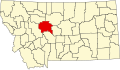 Map of Montana highlighting Cascade County.svg 9,194 × 5,303; 122 KB
-
 MTMap-doton-Belt.PNG 300 × 175; 12 KB
-
 MTMap-doton-BlackEagle.PNG 300 × 175; 12 KB
-
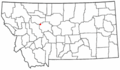
 MTMap-doton-Cascade.PNG 300 × 175; 12 KB
-
 MTMap-doton-FortShaw.PNG 300 × 175; 12 KB
-
 MTMap-doton-Simms.PNG 300 × 175; 12 KB
-
 MTMap-doton-Ulm.PNG 300 × 175; 12 KB
-
 MTMap-doton-Vaughn.PNG 300 × 175; 12 KB
-
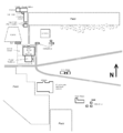
 Plan of Fort Shaw.png 1,400 × 2,390; 2.66 MB
-

-

-
 St Peters Mission layout - near Cascade Montana - c 1907.png 1,005 × 1,082; 71 KB


.jpg)
.jpg)
