Category:Maps of Crawford County, Arkansas
Counties of Arkansas: Arkansas · Ashley · Baxter · Benton · Boone · Bradley · Calhoun · Carroll · Chicot · Clark · Clay · Cleburne · Cleveland · Columbia · Conway · Craighead · Crawford · Crittenden · Cross · Dallas · Desha · Drew · Faulkner · Franklin · Fulton · Garland · Grant · Greene · Hempstead · Hot Spring · Howard · Independence · Izard · Jackson · Jefferson · Johnson · Lafayette · Lawrence · Lee · Lincoln · Little River · Logan · Lonoke · Madison · Marion · Miller · Mississippi · Monroe · Montgomery · Nevada · Newton · Ouachita · Perry · Phillips · Pike · Poinsett · Polk · Pope · Prairie · Pulaski · Randolph · Saline · Scott · Searcy · Sebastian · Sevier · Sharp · St. Francis · Stone · Union · Van Buren · Washington · White · Woodruff · Yell
Wikimedia category | |||||
| Upload media | |||||
| Instance of | |||||
|---|---|---|---|---|---|
| Category combines topics | |||||
| Crawford County | |||||
county in Arkansas, United States  Здание окружного суда в городе Ван-Бьюрен  | |||||
| Instance of | |||||
| Named after | |||||
| Location | Arkansas | ||||
| Located in or next to body of water | |||||
| Capital | |||||
| Inception |
| ||||
| Population |
| ||||
| Area |
| ||||
| Different from | |||||
| official website | |||||
 | |||||
Subcategories
This category has the following 2 subcategories, out of 2 total.
Media in category "Maps of Crawford County, Arkansas"
The following 26 files are in this category, out of 26 total.
-
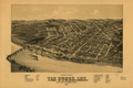
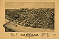 Perspective map of Van Buren, Ark. county seat of Crawford County 1888. LOC 75693085.jpg 8,368 × 5,536; 7.93 MB
-
 Perspective map of Van Buren, Ark. county seat of Crawford County 1888. LOC 75693085.tif 8,368 × 5,536; 132.54 MB
-
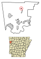
 ARMap-doton-Alma.png 300 × 262; 13 KB
-
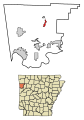
 ARMap-doton-Cedarville.png 300 × 262; 13 KB
-
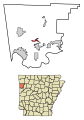
 ARMap-doton-Chester.png 300 × 262; 13 KB
-
 ARMap-doton-Dyer.png 300 × 262; 13 KB
-

-

-

-

-
-

-

-

-

-

-
-

-

-

-
-

-

-
-
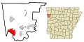
 Crawford County Arkansas.png 300 × 262; 15 KB
-
 Van Buren, Arkansas.png 522 × 346; 294 KB


