Category:Maps of Grant County, Wisconsin
Counties of Wisconsin: Adams · Ashland · Barron · Bayfield · Brown · Buffalo · Burnett · Calumet · Chippewa · Clark · Columbia · Crawford · Dane · Dodge · Door · Douglas · Dunn · Eau Claire · Florence · Fond du Lac · Forest · Grant · Green · Green Lake · Iowa · Iron · Jackson · Jefferson · Juneau · Kenosha · Kewaunee · La Crosse · Lafayette · Langlade · Lincoln · Manitowoc · Marathon · Marinette · Marquette · Menominee · Milwaukee · Monroe · Oconto · Oneida · Outagamie · Ozaukee · Pepin · Pierce · Polk · Portage · Price · Racine · Richland · Rock · Rusk · Sauk · Sawyer · Shawano · Sheboygan · St. Croix · Taylor · Trempealeau · Vernon · Vilas · Walworth · Washburn · Washington · Waukesha · Waupaca · Waushara · Winnebago · Wood
Wikimedia category | |||||
| Upload media | |||||
| Instance of | |||||
|---|---|---|---|---|---|
| Category combines topics | |||||
| Grant County | |||||
county in Wisconsin, United States   | |||||
| Instance of | |||||
| Named after |
| ||||
| Location | Wisconsin | ||||
| Capital | |||||
| Inception |
| ||||
| Population |
| ||||
| Area |
| ||||
| official website | |||||
 | |||||
Subcategories
This category has only the following subcategory.
Media in category "Maps of Grant County, Wisconsin"
The following 55 files are in this category, out of 55 total.
-
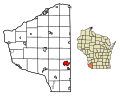
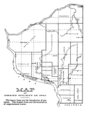 Grant County Wisconsin Civil Divisions 1843 Map.png 2,968 × 4,156; 11.78 MB
-

-

-

-

-

-
-
-

-

-

-

-
-

-

-

-
-

-

-

-
 Map of Wisconsin highlighting Grant County.svg 4,747 × 5,087; 103 KB
-
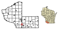
 MapHighlightingTownOfBeetownGrantCtWI.png 600 × 752; 115 KB
-
 MapHighlightingTownOfBloomingtonGrantCtWI.png 600 × 752; 114 KB
-
 MapHighlightingTownOfBoscobelGrantCtWI.png 600 × 752; 115 KB
-
 MapHighlightingTownOfCassvilleGrantCtWI.png 600 × 752; 113 KB
-
 MapHighlightingTownOfCastleRockGrantCtWI.png 600 × 752; 116 KB
-
 MapHighlightingTownOfCliftonGrantCtWI.png 600 × 752; 115 KB
-
 MapHighlightingTownOfEllenboroGrantCtWI.png 600 × 752; 116 KB
-
 MapHighlightingTownOfFennimoreGrantCtWI.png 600 × 752; 115 KB
-
 MapHighlightingTownOfGlenHavenGrantCtWI.png 600 × 752; 116 KB
-
 MapHighlightingTownOfHarrisonGrantCtWI.png 600 × 752; 116 KB
-
 MapHighlightingTownOfHazelGreenGrantCtWI.png 600 × 752; 115 KB
-
 MapHighlightingTownOfHickoryGroveGrantCtWI.png 600 × 752; 116 KB
-
 MapHighlightingTownOfJamestownGrantCtWI.png 600 × 752; 115 KB
-
 MapHighlightingTownOfLibertyGrantCtWI.png 600 × 752; 116 KB
-
 MapHighlightingTownOfLimaGrantCtWI.png 600 × 752; 116 KB
-
 MapHighlightingTownOfLittleGrantGrantCtWI.png 600 × 752; 116 KB
-
 MapHighlightingTownOfMarionGrantCtWI.png 600 × 752; 116 KB
-
 MapHighlightingTownOfMillvilleGrantCtWI.png 600 × 752; 115 KB
-
 MapHighlightingTownOfMountHopeGrantCtWI.png 600 × 752; 116 KB
-
 MapHighlightingTownOfMountIdaGrantCtWI.png 600 × 752; 116 KB
-
 MapHighlightingTownOfMuscadaGrantCtWI.png 600 × 752; 115 KB
-
 MapHighlightingTownOfNorthLancasterGrantCtWI.png 600 × 752; 116 KB
-
 MapHighlightingTownOfParisGrantCtWI.png 600 × 752; 116 KB
-
 MapHighlightingTownOfPatchGroveGrantCtWI.png 600 × 752; 115 KB
-
 MapHighlightingTownOfPlattevilleGrantCtWI.png 600 × 752; 114 KB
-
 MapHighlightingTownOfPotosiGrantCtWI.png 600 × 752; 112 KB
-
 MapHighlightingTownOfSmelserGrantCtWI.png 600 × 752; 116 KB
-
 MapHighlightingTownOfSouthLancasterGrantCtWI.png 600 × 752; 115 KB
-
 MapHighlightingTownOfWaterlooGrantCtWI.png 600 × 752; 115 KB
-
 MapHighlightingTownOfWatterstownGrantCtWI.png 600 × 752; 114 KB
-
 MapHighlightingTownOfWingvilleGrantCtWI.png 600 × 752; 116 KB
-
 MapHighlightingTownOfWoodmanGrantCtWI.png 600 × 752; 115 KB
-
 MapHighlightingTownOfWyalusingGrantCtWI.png 600 × 752; 114 KB
-
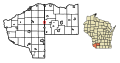
 TownsInGrantCt.png 600 × 752; 116 KB


