Category:Maps of Groix
Wikimedia category | |||||
| Upload media | |||||
| Instance of | |||||
|---|---|---|---|---|---|
| Category combines topics | |||||
| Groix | |||||
commune in Morbihan, France  .svg)  | |||||
| Pronunciation audio | |||||
| Instance of | |||||
| Location |
| ||||
| Located in or next to body of water | |||||
| Population |
| ||||
| Area |
| ||||
| Elevation above sea level |
| ||||
| Different from | |||||
| official website | |||||
 | |||||
Subcategories
This category has the following 2 subcategories, out of 2 total.
I
Î
Media in category "Maps of Groix"
The following 24 files are in this category, out of 24 total.
-
 56069-Groix-Hydro.jpeg 5,846 × 4,133; 1.5 MB
-
 56069-Groix-Routes-Hydro.png 3,507 × 2,480; 1.38 MB
-
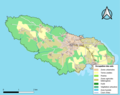 56069-Groix-Sols.png 3,270 × 2,598; 1.27 MB
-
-
 Admiralty Chart No 2352 Presqu'ile de Quiberon to Anse de Benodet, Published 1962.jpg 18,776 × 11,268; 44.34 MB
-

-
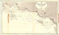
 Admiralty Chart No 2646 France west coast sheet 5 Bourgneuf to I. de Groix, Published 1858.jpg 12,274 × 8,384; 13.02 MB
-
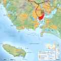
 Canton de Groix(Position).png 418 × 314; 38 KB
-
 Carte de Cassini Ile de Groix.jpg 1,493 × 703; 744 KB
-
 Carte des ports de l'Orient et Port Louis avec l'Isle de Grouais RMG F1994.tiff 8,682 × 4,110; 102.09 MB
-
 Ecomusée de Groix - dsmm07762.jpg 4,896 × 3,264; 6.54 MB
-
 Ecomusée de Groix - dsmm07764.jpg 4,896 × 3,264; 6.31 MB
-
 FR Ile de Groix.PNG 650 × 582; 17 KB
-
 Groix topographic map-fr.svg 1,066 × 708; 1.01 MB
-
 Ile de Groix - btv1b530149958.jpg 7,901 × 5,809; 4.94 MB
-
 Ile-de-Groix.png 800 × 549; 24 KB
-
 Kergroise topographic map-fr.svg 3,539 × 3,506; 1.34 MB
-
 Map commune FR insee code 56069.png 756 × 605; 32 KB
-
 Périmètre RNN François le Bail Ile de Groix rnn63.png 1,236 × 825; 360 KB
-
 Rade de Lorient topographic map-fr.svg 3,539 × 3,506; 1.34 MB
-
 Île de Groix - de St Pierre - btv1b53153619s.jpg 7,866 × 12,938; 10.09 MB
-
 Île de Groix - de St Pierre - btv1b531536205.jpg 7,934 × 12,620; 9.1 MB
-
 Île de Groix - de St Pierre - btv1b53153628r.jpg 6,384 × 11,654; 8.15 MB
-


.png)


.jpg)