Category:Maps of Henrico County, Virginia
Counties of Virginia: Accomack · Albemarle · Alleghany · Amelia · Amherst · Appomattox · Arlington · Augusta · Bath · Bedford · Bland · Botetourt · Brunswick · Buchanan · Buckingham · Campbell · Caroline · Carroll · Charles City · Charlotte · Chesterfield · Clarke · Craig · Culpeper · Cumberland · Dickenson · Dinwiddie · Essex · Fairfax · Fauquier · Floyd · Fluvanna · Franklin · Frederick · Giles · Gloucester · Goochland · Grayson · Greene · Greensville · Halifax · Hanover · Henrico · Henry · Highland · Isle of Wight · James City · King and Queen · King George · King William · Lancaster · Lee · Loudoun · Louisa · Lunenburg · Madison · Mathews · Mecklenburg · Middlesex · Montgomery · Nelson · New Kent · Northampton · Northumberland · Nottoway · Orange · Page · Patrick · Pittsylvania · Powhatan · Prince Edward · Prince George · Prince William · Pulaski · Rappahannock · Richmond · Roanoke · Rockbridge · Rockingham · Russell · Scott · Shenandoah · Smyth · Southampton · Spotsylvania · Stafford · Surry · Sussex · Tazewell · Warren · Washington · Westmoreland · Wise · Wythe · York
Wikimedia category | |||||
| Upload media | |||||
| Instance of | |||||
|---|---|---|---|---|---|
| Category combines topics | |||||
| Henrico County | |||||
county in Virginia, United States     | |||||
| Instance of | |||||
| Named after |
| ||||
| Location | Virginia | ||||
| Capital |
| ||||
| Inception |
| ||||
| Population |
| ||||
| Area |
| ||||
| Different from | |||||
| official website | |||||
 | |||||
Media in category "Maps of Henrico County, Virginia"
The following 35 files are in this category, out of 35 total.
-

-
 (Map of Henrico, Hanover and Caroline counties.) LOC 2003627094.tif 4,282 × 3,986; 48.83 MB
-
 1634 Virginia Counties- Henrico Focus.jpg 922 × 602; 229 KB
-
 Approximate Boundaries of the City of Henrico in 1619.jpg 1,040 × 779; 324 KB
-

-

-

-

-

-

-

-

-

-

-

-
 Deep Bottom August.png 1,780 × 1,789; 724 KB
-
 Deep Bottom July.png 1,780 × 1,789; 692 KB
-
 Map of Henrico County, Virginia - DPLA - 68f131b3e33d6ea016da258bc97a1b67.jpg 5,812 × 10,372; 4.12 MB
-
 Map of Virginia highlighting Henrico County.svg 7,486 × 3,247; 223 KB
-
 Map showing Henrico County, Virginia.png 750 × 485; 31 KB
-
 Richmond Metropolitan Area.png 638 × 293; 33 KB
-
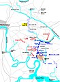 Seven Days June 30.jpg 1,537 × 2,097; 451 KB
-
-
 VAMap-doton-Chamberlayne.PNG 300 × 134; 9 KB
-
 VAMap-doton-Dumbarton.PNG 300 × 134; 9 KB
-
 VAMap-doton-EastHighlandPark.PNG 300 × 134; 9 KB
-
 VAMap-doton-GlenAllen.PNG 300 × 134; 9 KB
-
 VAMap-doton-Lakeside.PNG 300 × 134; 9 KB
-
 VAMap-doton-Laurel.PNG 300 × 134; 9 KB
-
 VAMap-doton-Montrose.PNG 300 × 134; 9 KB
-
 VAMap-doton-Sandston.PNG 300 × 134; 9 KB
-
 VAMap-doton-ShortPump.PNG 300 × 134; 9 KB
-
 VAMap-doton-Tuckahoe.PNG 300 × 134; 9 KB
-
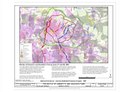
 Virginia Senate District 12 (2011).png 3,504 × 1,528; 682 KB
-
 Virginia Senate District 9 (2011).png 3,507 × 1,527; 686 KB
._LOC_2002627451.jpg)


.jpg)
.jpg)
.jpg)
.jpg)
.jpg)
.jpg)
.jpg)
.jpg)
.jpg)
.jpg)
.jpg)


.png)
.png)